You are here: Home > Network List > TA - USArray Transportable Network (new EarthScope stations) Stations List
> Station BNLO Ben Lomond (Santa Cruz Mountains), CA, USA > Earthquake Result Viewer
BNLO Ben Lomond (Santa Cruz Mountains), CA, USA - Earthquake Result Viewer
| Earthquake location: |
East Of Kuril Islands |
| Earthquake latitude/longitude: |
46.7/155.3 |
| Earthquake time(UTC): |
2006/11/15 (319) 11:34:58 GMT |
| Earthquake Depth: |
10 km |
| Earthquake Magnitude: |
6.4 MB |
| Earthquake Catalog/Contributor: |
WHDF/NEIC |
|
| Network: |
TA USArray Transportable Network (new EarthScope stations) |
| Station: |
BNLO Ben Lomond (Santa Cruz Mountains), CA, USA |
| Lat/Lon: |
37.13 N/122.17 W |
| Elevation: |
794 m |
|
| Distance: |
59.5 deg |
| Az: |
66.859 deg |
| Baz: |
307.572 deg |
| Ray Param: |
0.06213933 |
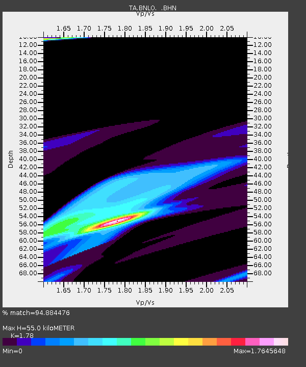
| Estimated Moho Depth: |
55.0 km |
| Estimated Crust Vp/Vs: |
1.78 |
| Assumed Crust Vp: |
6.183 km/s |
| Estimated Crust Vs: |
3.473 km/s |
| Estimated Crust Poisson's Ratio: |
0.27 |
|
| Radial Match: |
94.884476 % |
| Radial Bump: |
400 |
| Transverse Match: |
76.36367 % |
| Transverse Bump: |
328 |
| SOD ConfigId: |
2564 |
| Insert Time: |
2010-03-07 04:30:54.635 +0000 |
| GWidth: |
2.5 |
| Max Bumps: |
400 |
| Tol: |
0.001 |
|
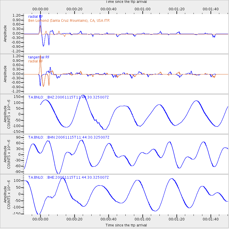
Signal To Noise
| Channel | StoN | STA | LTA |
| TA:BNLO: :BHN:20061115T11:44:30.325007Z | 1.106595 | 5.443046E-5 | 4.9187336E-5 |
| TA:BNLO: :BHE:20061115T11:44:30.325007Z | 1.2895749 | 1.1491659E-4 | 8.911199E-5 |
| TA:BNLO: :BHZ:20061115T11:44:30.325007Z | 0.692402 | 6.379915E-5 | 9.214177E-5 |
| Arrivals |
| Ps | 7.2 SECOND |
| PpPs | 24 SECOND |
| PsPs/PpSs | 31 SECOND |


