You are here: Home > Network List > N4 - Central and EAstern US Network Stations List
> Station MSTX Muleshoe, TX, USA > Earthquake Result Viewer
MSTX Muleshoe, TX, USA - Earthquake Result Viewer
| Earthquake location: |
Mona Passage |
| Earthquake latitude/longitude: |
19.2/-67.2 |
| Earthquake time(UTC): |
2019/09/24 (267) 03:23:33 GMT |
| Earthquake Depth: |
10 km |
| Earthquake Magnitude: |
6.3 Mi |
| Earthquake Catalog/Contributor: |
NEIC PDE/at |
|
| Network: |
N4 Central and EAstern US Network |
| Station: |
MSTX Muleshoe, TX, USA |
| Lat/Lon: |
33.97 N/102.77 W |
| Elevation: |
1167 m |
|
| Distance: |
34.9 deg |
| Az: |
302.216 deg |
| Baz: |
105.827 deg |
| Ray Param: |
0.077528544 |
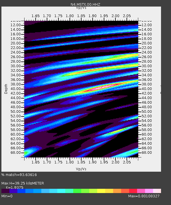
| Estimated Moho Depth: |
39.25 km |
| Estimated Crust Vp/Vs: |
1.94 |
| Assumed Crust Vp: |
6.129 km/s |
| Estimated Crust Vs: |
3.163 km/s |
| Estimated Crust Poisson's Ratio: |
0.32 |
|
| Radial Match: |
93.63616 % |
| Radial Bump: |
333 |
| Transverse Match: |
65.41312 % |
| Transverse Bump: |
400 |
| SOD ConfigId: |
19053131 |
| Insert Time: |
2019-10-08 03:28:35.481 +0000 |
| GWidth: |
2.5 |
| Max Bumps: |
400 |
| Tol: |
0.001 |
|

Signal To Noise
| Channel | StoN | STA | LTA |
| N4:MSTX:00:HHZ:20190924T03:29:53.398987Z | 2.4191232 | 3.0031813E-7 | 1.2414338E-7 |
| N4:MSTX:00:HH1:20190924T03:29:53.398987Z | 1.5270442 | 1.7701994E-7 | 1.15923264E-7 |
| N4:MSTX:00:HH2:20190924T03:29:53.398987Z | 2.2387743 | 2.1770164E-7 | 9.724145E-8 |
| Arrivals |
| Ps | 6.4 SECOND |
| PpPs | 18 SECOND |
| PsPs/PpSs | 24 SECOND |


