You are here: Home > Network List > TA - USArray Transportable Network (new EarthScope stations) Stations List
> Station BNLO Ben Lomond (Santa Cruz Mountains), CA, USA > Earthquake Result Viewer
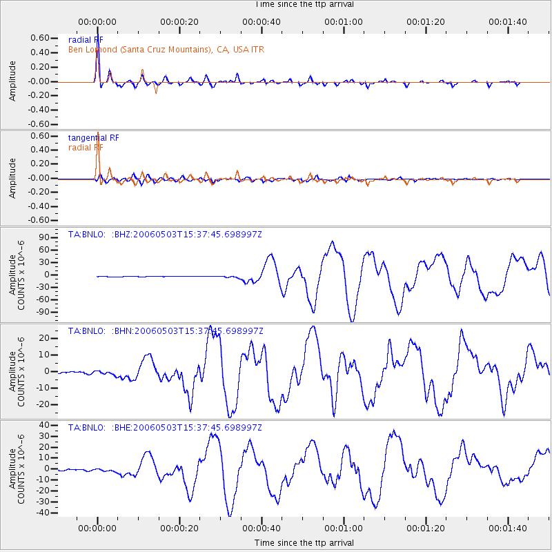
BNLO Ben Lomond (Santa Cruz Mountains), CA, USA - Earthquake Result Viewer
| Earthquake location: |
Tonga Islands |
| Earthquake latitude/longitude: |
-20.2/-174.1 |
| Earthquake time(UTC): |
2006/05/03 (123) 15:26:40 GMT |
| Earthquake Depth: |
55 km |
| Earthquake Magnitude: |
7.2 MB, 7.8 MS, 7.9 MW, 7.9 MW |
| Earthquake Catalog/Contributor: |
WHDF/NEIC |
|
| Network: |
TA USArray Transportable Network (new EarthScope stations) |
| Station: |
BNLO Ben Lomond (Santa Cruz Mountains), CA, USA |
| Lat/Lon: |
37.13 N/122.17 W |
| Elevation: |
794 m |
|
| Distance: |
75.1 deg |
| Az: |
40.627 deg |
| Baz: |
229.933 deg |
| Ray Param: |
0.05176369 |
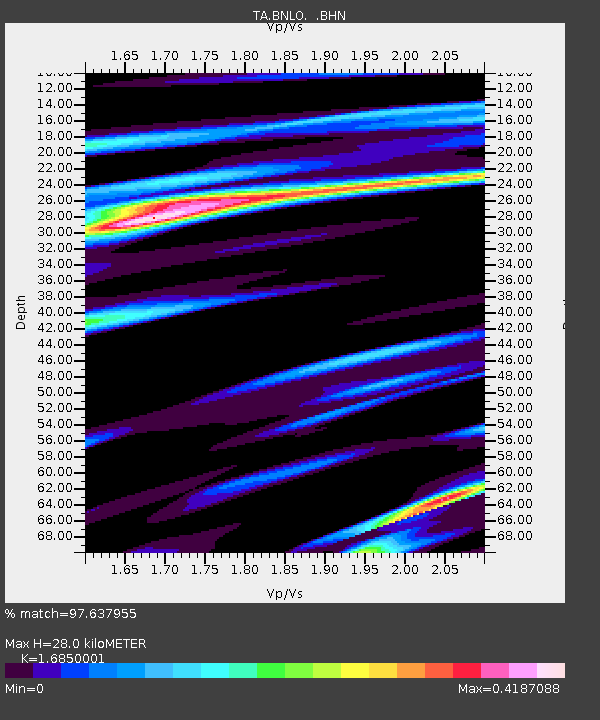
| Estimated Moho Depth: |
28.0 km |
| Estimated Crust Vp/Vs: |
1.69 |
| Assumed Crust Vp: |
6.183 km/s |
| Estimated Crust Vs: |
3.669 km/s |
| Estimated Crust Poisson's Ratio: |
0.23 |
|
| Radial Match: |
97.637955 % |
| Radial Bump: |
330 |
| Transverse Match: |
88.30813 % |
| Transverse Bump: |
400 |
| SOD ConfigId: |
2669 |
| Insert Time: |
2010-03-07 04:31:12.859 +0000 |
| GWidth: |
2.5 |
| Max Bumps: |
400 |
| Tol: |
0.001 |
|
Signal To Noise
| Channel | StoN | STA | LTA |
| TA:BNLO: :BHN:20060503T15:37:45.698997Z | 2.5715532 | 1.2087182E-6 | 4.700343E-7 |
| TA:BNLO: :BHE:20060503T15:37:45.698997Z | 1.5845654 | 1.1220787E-6 | 7.0813024E-7 |
| TA:BNLO: :BHZ:20060503T15:37:45.698997Z | 3.863705 | 2.4681724E-6 | 6.3880975E-7 |
| Arrivals |
| Ps | 3.2 SECOND |
| PpPs | 12 SECOND |
| PsPs/PpSs | 15 SECOND |


