You are here: Home > Network List > US - United States National Seismic Network Stations List
> Station MNTX Cornudas Mountains, Texas, USA > Earthquake Result Viewer
MNTX Cornudas Mountains, Texas, USA - Earthquake Result Viewer
| Earthquake location: |
Mona Passage |
| Earthquake latitude/longitude: |
19.2/-67.2 |
| Earthquake time(UTC): |
2019/09/24 (267) 03:23:33 GMT |
| Earthquake Depth: |
10 km |
| Earthquake Magnitude: |
6.3 Mi |
| Earthquake Catalog/Contributor: |
NEIC PDE/at |
|
| Network: |
US United States National Seismic Network |
| Station: |
MNTX Cornudas Mountains, Texas, USA |
| Lat/Lon: |
31.70 N/105.38 W |
| Elevation: |
404 m |
|
| Distance: |
36.5 deg |
| Az: |
297.572 deg |
| Baz: |
100.644 deg |
| Ray Param: |
0.076662205 |
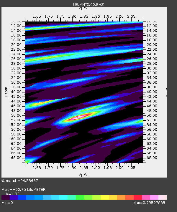
| Estimated Moho Depth: |
50.75 km |
| Estimated Crust Vp/Vs: |
1.82 |
| Assumed Crust Vp: |
6.361 km/s |
| Estimated Crust Vs: |
3.495 km/s |
| Estimated Crust Poisson's Ratio: |
0.28 |
|
| Radial Match: |
94.58687 % |
| Radial Bump: |
284 |
| Transverse Match: |
74.336525 % |
| Transverse Bump: |
400 |
| SOD ConfigId: |
19053131 |
| Insert Time: |
2019-10-08 03:30:57.853 +0000 |
| GWidth: |
2.5 |
| Max Bumps: |
400 |
| Tol: |
0.001 |
|

Signal To Noise
| Channel | StoN | STA | LTA |
| US:MNTX:00:BHZ:20190924T03:30:07.299988Z | 4.1026583 | 3.32556E-7 | 8.105867E-8 |
| US:MNTX:00:BH1:20190924T03:30:07.299988Z | 1.349308 | 1.5011616E-7 | 1.1125418E-7 |
| US:MNTX:00:BH2:20190924T03:30:07.299988Z | 2.64598 | 1.8288962E-7 | 6.9119814E-8 |
| Arrivals |
| Ps | 7.0 SECOND |
| PpPs | 21 SECOND |
| PsPs/PpSs | 28 SECOND |


