You are here: Home > Network List > TA - USArray Transportable Network (new EarthScope stations) Stations List
> Station H11A Donnelly, ID, USA > Earthquake Result Viewer
H11A Donnelly, ID, USA - Earthquake Result Viewer
| Earthquake location: |
Volcano Islands, Japan Region |
| Earthquake latitude/longitude: |
22.0/142.7 |
| Earthquake time(UTC): |
2007/09/28 (271) 13:38:59 GMT |
| Earthquake Depth: |
276 km |
| Earthquake Magnitude: |
6.7 MB, 7.4 MW, 7.4 MW |
| Earthquake Catalog/Contributor: |
WHDF/NEIC |
|
| Network: |
TA USArray Transportable Network (new EarthScope stations) |
| Station: |
H11A Donnelly, ID, USA |
| Lat/Lon: |
44.70 N/116.01 W |
| Elevation: |
1525 m |
|
| Distance: |
82.5 deg |
| Az: |
44.853 deg |
| Baz: |
293.388 deg |
| Ray Param: |
0.046163242 |
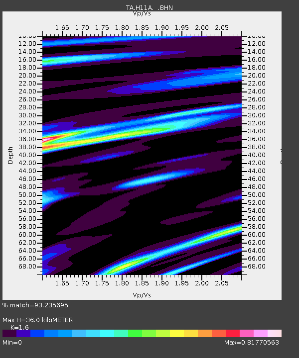
| Estimated Moho Depth: |
36.0 km |
| Estimated Crust Vp/Vs: |
1.60 |
| Assumed Crust Vp: |
6.571 km/s |
| Estimated Crust Vs: |
4.107 km/s |
| Estimated Crust Poisson's Ratio: |
0.18 |
|
| Radial Match: |
93.235695 % |
| Radial Bump: |
400 |
| Transverse Match: |
77.84211 % |
| Transverse Bump: |
400 |
| SOD ConfigId: |
2564 |
| Insert Time: |
2010-03-07 04:31:43.388 +0000 |
| GWidth: |
2.5 |
| Max Bumps: |
400 |
| Tol: |
0.001 |
|

Signal To Noise
| Channel | StoN | STA | LTA |
| TA:H11A: :BHN:20070928T13:50:20.099011Z | 8.063971 | 1.5140752E-6 | 1.8775802E-7 |
| TA:H11A: :BHE:20070928T13:50:20.099011Z | 27.93532 | 3.3846386E-6 | 1.2115983E-7 |
| TA:H11A: :BHZ:20070928T13:50:20.099011Z | 70.9821 | 1.0769356E-5 | 1.5171932E-7 |
| Arrivals |
| Ps | 3.4 SECOND |
| PpPs | 14 SECOND |
| PsPs/PpSs | 17 SECOND |


