You are here: Home > Network List > G - GEOSCOPE Stations List
> Station CRZF Port Alfred, Crozet, South Indian Ocean > Earthquake Result Viewer
CRZF Port Alfred, Crozet, South Indian Ocean - Earthquake Result Viewer
| Earthquake location: |
Solomon Islands |
| Earthquake latitude/longitude: |
-6.2/155.1 |
| Earthquake time(UTC): |
2017/01/22 (022) 04:30:23 GMT |
| Earthquake Depth: |
136 km |
| Earthquake Magnitude: |
7.9 mww |
| Earthquake Catalog/Contributor: |
NEIC PDE/us |
|
| Network: |
G GEOSCOPE |
| Station: |
CRZF Port Alfred, Crozet, South Indian Ocean |
| Lat/Lon: |
46.43 S/51.86 E |
| Elevation: |
140 m |
|
| Distance: |
94.6 deg |
| Az: |
222.485 deg |
| Baz: |
103.878 deg |
| Ray Param: |
0.04090413 |
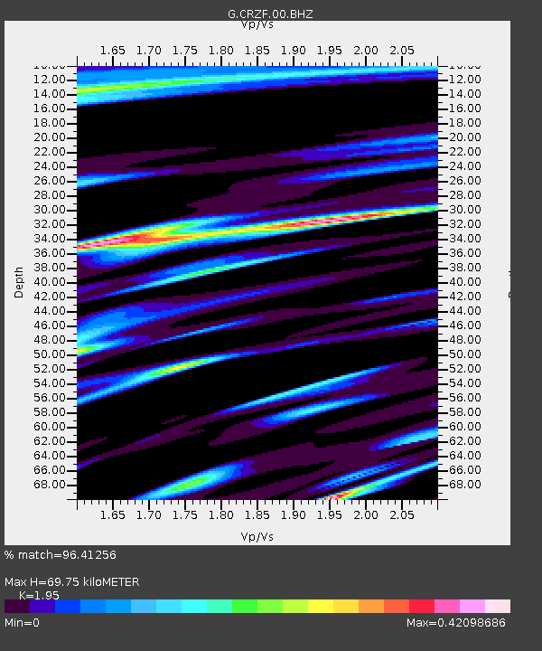
| Estimated Moho Depth: |
69.75 km |
| Estimated Crust Vp/Vs: |
1.95 |
| Assumed Crust Vp: |
4.802 km/s |
| Estimated Crust Vs: |
2.463 km/s |
| Estimated Crust Poisson's Ratio: |
0.32 |
|
| Radial Match: |
96.41256 % |
| Radial Bump: |
344 |
| Transverse Match: |
79.71314 % |
| Transverse Bump: |
400 |
| SOD ConfigId: |
1943534 |
| Insert Time: |
2017-02-05 04:31:36.252 +0000 |
| GWidth: |
2.5 |
| Max Bumps: |
400 |
| Tol: |
0.001 |
|
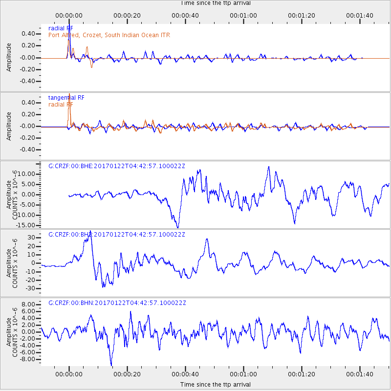
Signal To Noise
| Channel | StoN | STA | LTA |
| G:CRZF:00:BHZ:20170122T04:42:57.100022Z | 6.680114 | 7.613117E-6 | 1.1396687E-6 |
| G:CRZF:00:BHN:20170122T04:42:57.100022Z | 1.2649311 | 1.1200585E-6 | 8.8547E-7 |
| G:CRZF:00:BHE:20170122T04:42:57.100022Z | 3.3497896 | 3.1959876E-6 | 9.54086E-7 |
| Arrivals |
| Ps | 14 SECOND |
| PpPs | 42 SECOND |
| PsPs/PpSs | 56 SECOND |


