You are here: Home > Network List > TA - USArray Transportable Network (new EarthScope stations) Stations List
> Station H11A Donnelly, ID, USA > Earthquake Result Viewer
H11A Donnelly, ID, USA - Earthquake Result Viewer
| Earthquake location: |
Vanuatu Islands |
| Earthquake latitude/longitude: |
-15.6/167.7 |
| Earthquake time(UTC): |
2007/08/01 (213) 17:08:51 GMT |
| Earthquake Depth: |
120 km |
| Earthquake Magnitude: |
6.2 MB, 7.2 MW, 7.2 MW |
| Earthquake Catalog/Contributor: |
WHDF/NEIC |
|
| Network: |
TA USArray Transportable Network (new EarthScope stations) |
| Station: |
H11A Donnelly, ID, USA |
| Lat/Lon: |
44.70 N/116.01 W |
| Elevation: |
1525 m |
|
| Distance: |
91.4 deg |
| Az: |
43.873 deg |
| Baz: |
249.48 deg |
| Ray Param: |
0.04156243 |
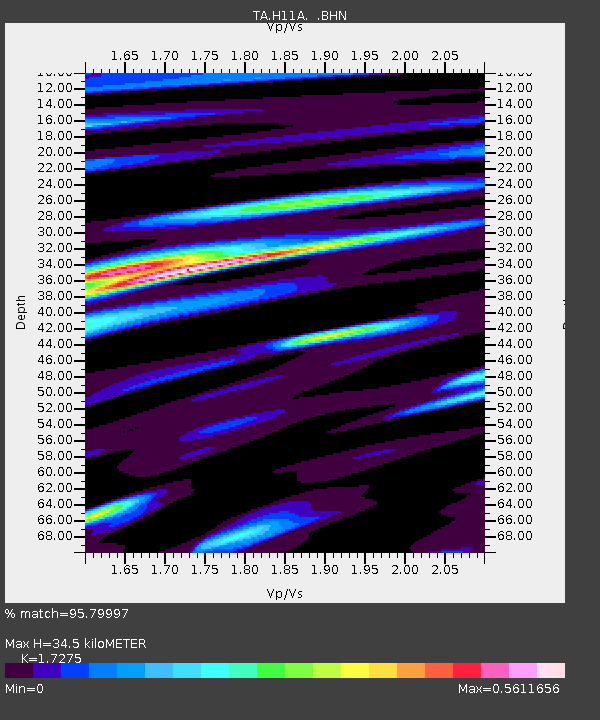
| Estimated Moho Depth: |
34.5 km |
| Estimated Crust Vp/Vs: |
1.73 |
| Assumed Crust Vp: |
6.571 km/s |
| Estimated Crust Vs: |
3.804 km/s |
| Estimated Crust Poisson's Ratio: |
0.25 |
|
| Radial Match: |
95.79997 % |
| Radial Bump: |
370 |
| Transverse Match: |
83.46168 % |
| Transverse Bump: |
400 |
| SOD ConfigId: |
2564 |
| Insert Time: |
2010-03-07 04:32:01.178 +0000 |
| GWidth: |
2.5 |
| Max Bumps: |
400 |
| Tol: |
0.001 |
|

Signal To Noise
| Channel | StoN | STA | LTA |
| TA:H11A: :BHN:20070801T17:21:12.675024Z | 0.6886242 | 8.313525E-8 | 1.2072657E-7 |
| TA:H11A: :BHE:20070801T17:21:12.675024Z | 1.5651051 | 1.6654408E-7 | 1.06410795E-7 |
| TA:H11A: :BHZ:20070801T17:21:12.675024Z | 6.7860355 | 6.394575E-7 | 9.4231375E-8 |
| Arrivals |
| Ps | 3.9 SECOND |
| PpPs | 14 SECOND |
| PsPs/PpSs | 18 SECOND |


