You are here: Home > Network List > TA - USArray Transportable Network (new EarthScope stations) Stations List
> Station H11A Donnelly, ID, USA > Earthquake Result Viewer
H11A Donnelly, ID, USA - Earthquake Result Viewer
| Earthquake location: |
Sea Of Japan |
| Earthquake latitude/longitude: |
36.8/134.9 |
| Earthquake time(UTC): |
2007/07/16 (197) 14:17:37 GMT |
| Earthquake Depth: |
350 km |
| Earthquake Magnitude: |
6.2 MB, 6.8 MW, 6.8 MW |
| Earthquake Catalog/Contributor: |
WHDF/NEIC |
|
| Network: |
TA USArray Transportable Network (new EarthScope stations) |
| Station: |
H11A Donnelly, ID, USA |
| Lat/Lon: |
44.70 N/116.01 W |
| Elevation: |
1525 m |
|
| Distance: |
76.7 deg |
| Az: |
43.817 deg |
| Baz: |
308.811 deg |
| Ray Param: |
0.04985271 |
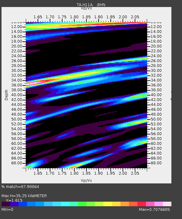
| Estimated Moho Depth: |
35.25 km |
| Estimated Crust Vp/Vs: |
1.62 |
| Assumed Crust Vp: |
6.571 km/s |
| Estimated Crust Vs: |
4.069 km/s |
| Estimated Crust Poisson's Ratio: |
0.19 |
|
| Radial Match: |
87.98864 % |
| Radial Bump: |
400 |
| Transverse Match: |
62.20657 % |
| Transverse Bump: |
400 |
| SOD ConfigId: |
2564 |
| Insert Time: |
2010-03-07 04:32:05.864 +0000 |
| GWidth: |
2.5 |
| Max Bumps: |
400 |
| Tol: |
0.001 |
|

Signal To Noise
| Channel | StoN | STA | LTA |
| TA:H11A: :BHN:20070716T14:28:19.37302Z | 8.429836 | 3.6987177E-7 | 4.3876504E-8 |
| TA:H11A: :BHE:20070716T14:28:19.37302Z | 9.062164 | 3.624422E-7 | 3.9995104E-8 |
| TA:H11A: :BHZ:20070716T14:28:19.37302Z | 23.820232 | 1.2851846E-6 | 5.395349E-8 |
| Arrivals |
| Ps | 3.4 SECOND |
| PpPs | 14 SECOND |
| PsPs/PpSs | 17 SECOND |


