You are here: Home > Network List > TA - USArray Transportable Network (new EarthScope stations) Stations List
> Station H11A Donnelly, ID, USA > Earthquake Result Viewer
H11A Donnelly, ID, USA - Earthquake Result Viewer
| Earthquake location: |
Northern Mid-Atlantic Ridge |
| Earthquake latitude/longitude: |
52.4/-31.8 |
| Earthquake time(UTC): |
2007/05/23 (143) 04:41:46 GMT |
| Earthquake Depth: |
10 km |
| Earthquake Magnitude: |
5.6 MS, 5.4 MB, 5.7 MW, 5.6 MW |
| Earthquake Catalog/Contributor: |
WHDF/NEIC |
|
| Network: |
TA USArray Transportable Network (new EarthScope stations) |
| Station: |
H11A Donnelly, ID, USA |
| Lat/Lon: |
44.70 N/116.01 W |
| Elevation: |
1525 m |
|
| Distance: |
53.3 deg |
| Az: |
297.738 deg |
| Baz: |
49.579 deg |
| Ray Param: |
0.06620532 |
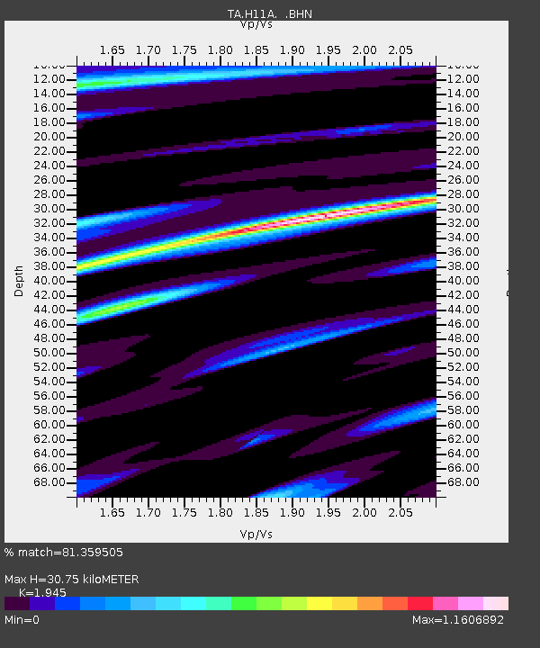
| Estimated Moho Depth: |
30.75 km |
| Estimated Crust Vp/Vs: |
1.95 |
| Assumed Crust Vp: |
6.571 km/s |
| Estimated Crust Vs: |
3.378 km/s |
| Estimated Crust Poisson's Ratio: |
0.32 |
|
| Radial Match: |
81.359505 % |
| Radial Bump: |
400 |
| Transverse Match: |
66.642876 % |
| Transverse Bump: |
400 |
| SOD ConfigId: |
2564 |
| Insert Time: |
2010-03-07 04:32:15.770 +0000 |
| GWidth: |
2.5 |
| Max Bumps: |
400 |
| Tol: |
0.001 |
|

Signal To Noise
| Channel | StoN | STA | LTA |
| TA:H11A: :BHN:20070523T04:50:34.399009Z | 4.728019 | 2.1329288E-7 | 4.511252E-8 |
| TA:H11A: :BHE:20070523T04:50:34.399009Z | 1.8881682 | 1.8326256E-7 | 9.705839E-8 |
| TA:H11A: :BHZ:20070523T04:50:34.399009Z | 8.575846 | 5.300539E-7 | 6.1807775E-8 |
| Arrivals |
| Ps | 4.7 SECOND |
| PpPs | 13 SECOND |
| PsPs/PpSs | 18 SECOND |


