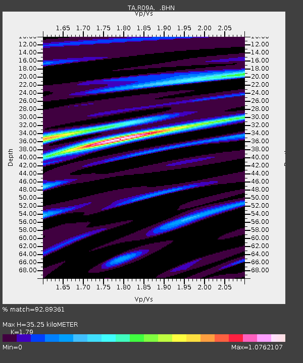
R09A Tonopah, NV, USA - Earthquake Result Viewer
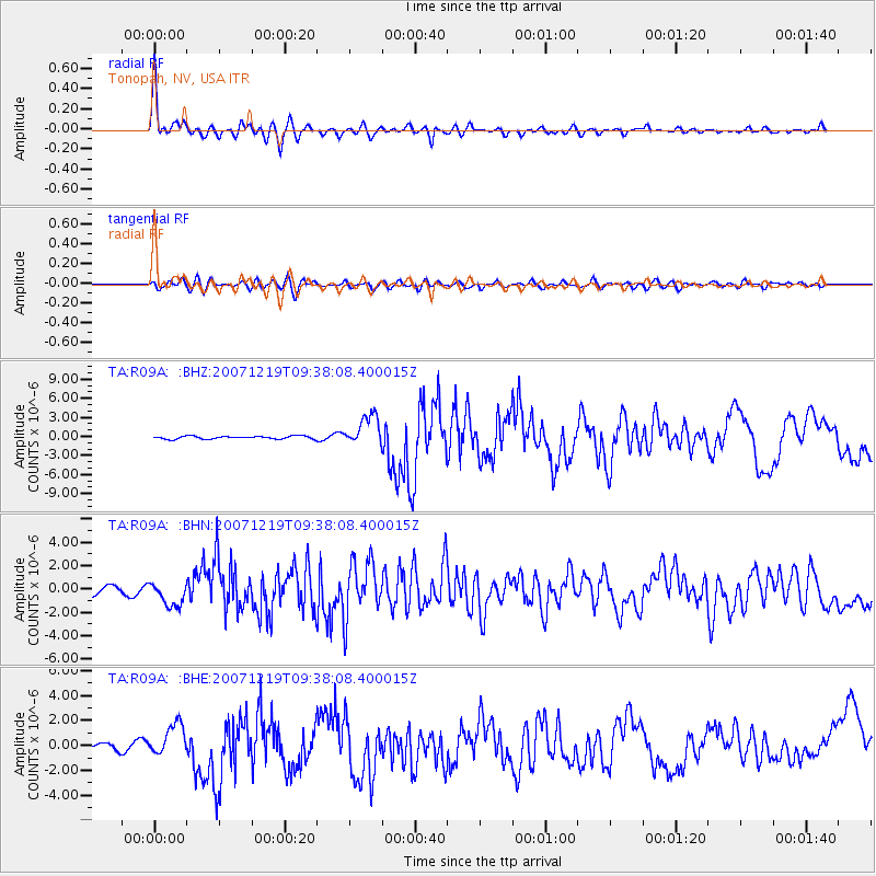
Earthquake location: Andreanof Islands, Aleutian Is.
Earthquake latitude/longitude: 51.4/-179.5
Earthquake time(UTC): 2007/12/19 (353) 09:30:27 GMT
Earthquake Depth: 29 km
Earthquake Magnitude: 6.4 MB, 7.1 MS, 7.1 MW, 7.0 MW
Earthquake Catalog/Contributor: WHDF/NEIC
Network: TA USArray Transportable Network (new EarthScope stations)
Station: R09A Tonopah, NV, USA
Lat/Lon: 38.24 N/117.07 W
Elevation: 1759 m
Distance: 44.9 deg
Az: 81.632 deg
Baz: 308.029 deg
Ray Param: 0.071587324
Estimated Moho Depth: 35.25 km
Estimated Crust Vp/Vs: 1.79
Assumed Crust Vp: 6.276 km/s
Estimated Crust Vs: 3.506 km/s
Estimated Crust Poisson's Ratio: 0.27
Radial Match: 92.89361 %
Radial Bump: 395
Transverse Match: 81.96184 %
Transverse Bump: 400
SOD ConfigId: 2564
Insert Time: 2010-03-07 04:32:25.535 +0000
GWidth: 2.5
Max Bumps: 400
Tol: 0.001

Signal To Noise

ChannelStoNSTALTA
TA:R09A: :BHN:20071219T09:38:08.400015Z2.9259031.0162803E-63.4733904E-7
TA:R09A: :BHE:20071219T09:38:08.400015Z8.3526361.296322E-61.5519913E-7
TA:R09A: :BHZ:20071219T09:38:08.400015Z10.1541612.4025646E-62.3660887E-7
Arrivals
Ps4.7 SECOND
PpPs15 SECOND
PsPs/PpSs19 SECOND