You are here: Home > Network List > TA - USArray Transportable Network (new EarthScope stations) Stations List
> Station R09A Tonopah, NV, USA > Earthquake Result Viewer
R09A Tonopah, NV, USA - Earthquake Result Viewer
| Earthquake location: |
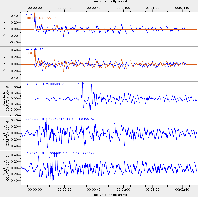
Sakhalin, Russia |
| Earthquake latitude/longitude: |
46.5/141.9 |
| Earthquake time(UTC): |
2006/08/17 (229) 15:20:35 GMT |
| Earthquake Depth: |
17 km |
| Earthquake Magnitude: |
6.0 MB, 5.2 MS, 5.6 MW, 5.5 MW |
| Earthquake Catalog/Contributor: |
WHDF/NEIC |
|
| Network: |
TA USArray Transportable Network (new EarthScope stations) |
| Station: |
R09A Tonopah, NV, USA |
| Lat/Lon: |
38.24 N/117.07 W |
| Elevation: |
1759 m |
|
| Distance: |
70.0 deg |
| Az: |
55.339 deg |
| Baz: |
313.86 deg |
| Ray Param: |
0.055260915 |
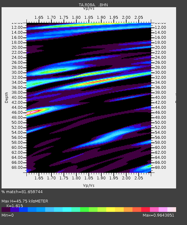
| Estimated Moho Depth: |
45.75 km |
| Estimated Crust Vp/Vs: |
1.62 |
| Assumed Crust Vp: |
6.276 km/s |
| Estimated Crust Vs: |
3.886 km/s |
| Estimated Crust Poisson's Ratio: |
0.19 |
|
| Radial Match: |
81.659744 % |
| Radial Bump: |
400 |
| Transverse Match: |
70.66636 % |
| Transverse Bump: |
400 |
| SOD ConfigId: |
2564 |
| Insert Time: |
2010-03-07 04:32:33.849 +0000 |
| GWidth: |
2.5 |
| Max Bumps: |
400 |
| Tol: |
0.001 |
|
Signal To Noise
| Channel | StoN | STA | LTA |
| TA:R09A: :BHN:20060817T15:31:14.849019Z | 2.61105 | 1.3569932E-7 | 5.1971174E-8 |
| TA:R09A: :BHE:20060817T15:31:14.849019Z | 2.9608307 | 1.6905494E-7 | 5.7097136E-8 |
| TA:R09A: :BHZ:20060817T15:31:14.849019Z | 6.1186695 | 4.9622014E-7 | 8.109935E-8 |
| Arrivals |
| Ps | 4.7 SECOND |
| PpPs | 18 SECOND |
| PsPs/PpSs | 23 SECOND |


