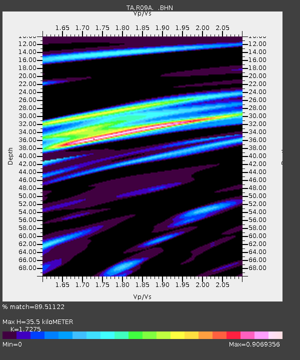
R09A Tonopah, NV, USA - Earthquake Result Viewer
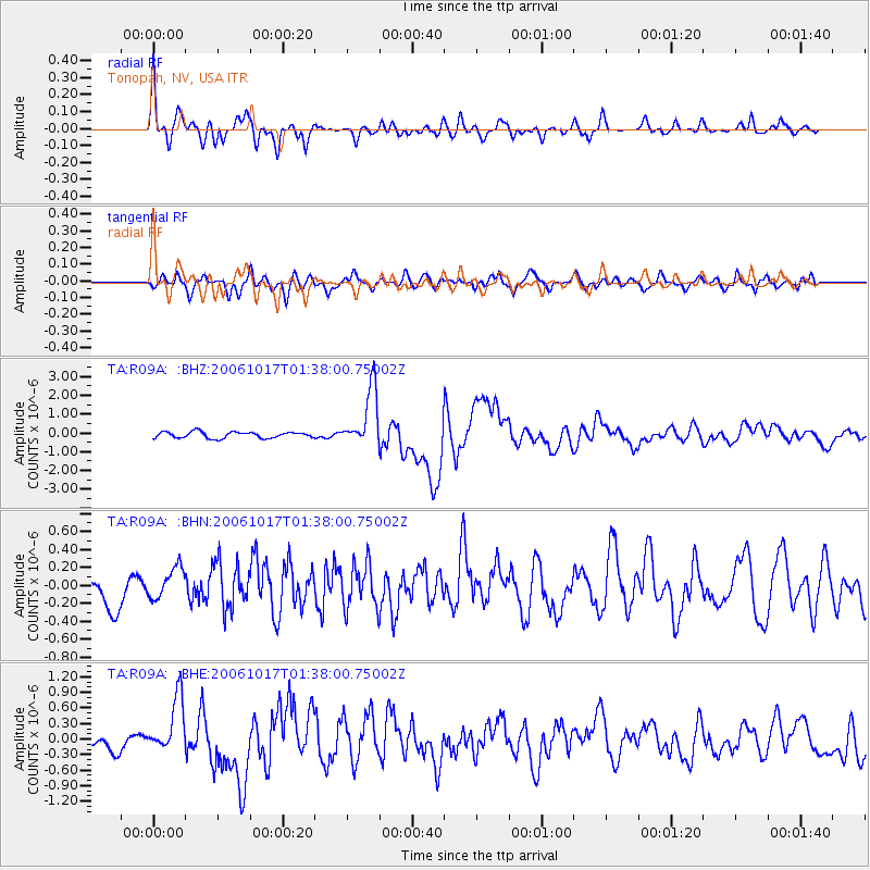
Earthquake location: New Britain Region, P.N.G.
Earthquake latitude/longitude: -5.9/151.0
Earthquake time(UTC): 2006/10/17 (290) 01:25:12 GMT
Earthquake Depth: 32 km
Earthquake Magnitude: 6.4 MB, 6.9 MS, 6.7 MW, 6.6 MW
Earthquake Catalog/Contributor: WHDF/NEIC
Network: TA USArray Transportable Network (new EarthScope stations)
Station: R09A Tonopah, NV, USA
Lat/Lon: 38.24 N/117.07 W
Elevation: 1759 m
Distance: 95.1 deg
Az: 52.199 deg
Baz: 266.585 deg
Ray Param: 0.04085145
Estimated Moho Depth: 35.5 km
Estimated Crust Vp/Vs: 1.73
Assumed Crust Vp: 6.276 km/s
Estimated Crust Vs: 3.633 km/s
Estimated Crust Poisson's Ratio: 0.25
Radial Match: 89.51122 %
Radial Bump: 400
Transverse Match: 75.39465 %
Transverse Bump: 400
SOD ConfigId: 2665
Insert Time: 2010-03-07 04:32:41.039 +0000
GWidth: 2.5
Max Bumps: 400
Tol: 0.001

Signal To Noise

ChannelStoNSTALTA
TA:R09A: :BHN:20061017T01:38:00.75002Z1.0575881.6832853E-71.5916267E-7
TA:R09A: :BHE:20061017T01:38:00.75002Z3.4620375.292054E-71.5285954E-7
TA:R09A: :BHZ:20061017T01:38:00.75002Z9.5067481.5681945E-61.6495594E-7
Arrivals
Ps4.2 SECOND
PpPs15 SECOND
PsPs/PpSs19 SECOND