You are here: Home > Network List > IU - Global Seismograph Network (GSN - IRIS/USGS) Stations List
> Station MA2 Magadan, Russia > Earthquake Result Viewer
MA2 Magadan, Russia - Earthquake Result Viewer
| Earthquake location: |
Solomon Islands |
| Earthquake latitude/longitude: |
-6.2/155.1 |
| Earthquake time(UTC): |
2017/01/22 (022) 04:30:23 GMT |
| Earthquake Depth: |
136 km |
| Earthquake Magnitude: |
7.9 mww |
| Earthquake Catalog/Contributor: |
NEIC PDE/us |
|
| Network: |
IU Global Seismograph Network (GSN - IRIS/USGS) |
| Station: |
MA2 Magadan, Russia |
| Lat/Lon: |
59.58 N/150.77 E |
| Elevation: |
339 m |
|
| Distance: |
65.7 deg |
| Az: |
357.571 deg |
| Baz: |
175.25 deg |
| Ray Param: |
0.05773906 |
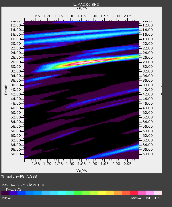
| Estimated Moho Depth: |
27.75 km |
| Estimated Crust Vp/Vs: |
1.88 |
| Assumed Crust Vp: |
6.134 km/s |
| Estimated Crust Vs: |
3.271 km/s |
| Estimated Crust Poisson's Ratio: |
0.30 |
|
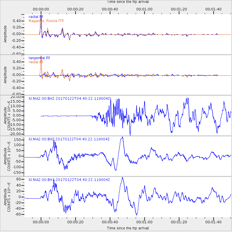
| Radial Match: |
98.71388 % |
| Radial Bump: |
321 |
| Transverse Match: |
92.944115 % |
| Transverse Bump: |
400 |
| SOD ConfigId: |
1943534 |
| Insert Time: |
2017-02-05 04:32:18.147 +0000 |
| GWidth: |
2.5 |
| Max Bumps: |
400 |
| Tol: |
0.001 |
|
Signal To Noise
| Channel | StoN | STA | LTA |
| IU:MA2:00:BHZ:20170122T04:40:22.119004Z | 11.582994 | 2.4551198E-5 | 2.11959E-6 |
| IU:MA2:00:BH1:20170122T04:40:22.119004Z | 10.355352 | 9.970896E-6 | 9.628736E-7 |
| IU:MA2:00:BH2:20170122T04:40:22.119004Z | 13.989056 | 1.8437172E-6 | 1.3179712E-7 |
| Arrivals |
| Ps | 4.1 SECOND |
| PpPs | 13 SECOND |
| PsPs/PpSs | 17 SECOND |


