You are here: Home > Network List > IU - Global Seismograph Network (GSN - IRIS/USGS) Stations List
> Station JOHN Johnston Island, USA > Earthquake Result Viewer
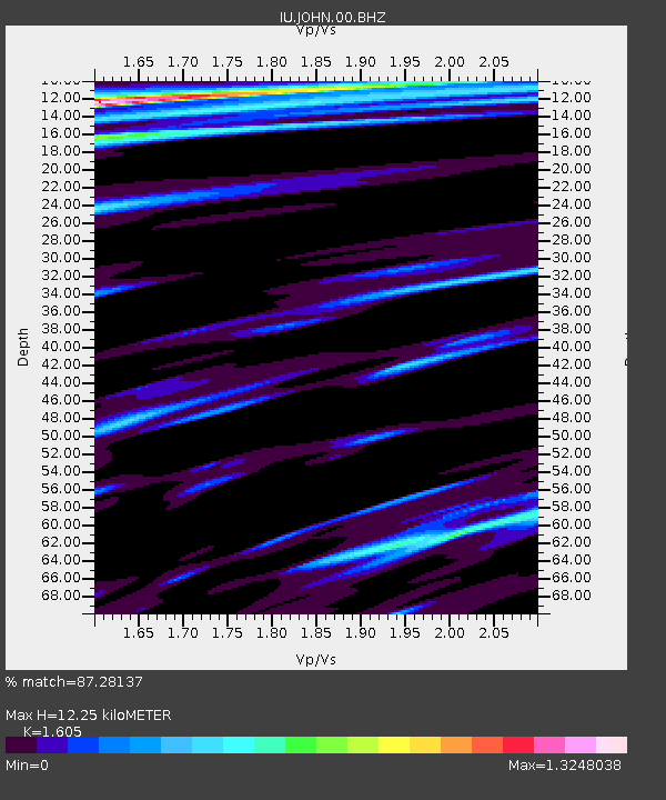
JOHN Johnston Island, USA - Earthquake Result Viewer
| Earthquake location: |
Solomon Islands |
| Earthquake latitude/longitude: |
-6.2/155.1 |
| Earthquake time(UTC): |
2017/01/22 (022) 04:30:23 GMT |
| Earthquake Depth: |
136 km |
| Earthquake Magnitude: |
7.9 mww |
| Earthquake Catalog/Contributor: |
NEIC PDE/us |
|
| Network: |
IU Global Seismograph Network (GSN - IRIS/USGS) |
| Station: |
JOHN Johnston Island, USA |
| Lat/Lon: |
16.73 N/169.53 W |
| Elevation: |
2.0 m |
|
| Distance: |
41.7 deg |
| Az: |
56.386 deg |
| Baz: |
239.778 deg |
| Ray Param: |
0.07311953 |
| Estimated Moho Depth: |
12.25 km |
| Estimated Crust Vp/Vs: |
1.61 |
| Assumed Crust Vp: |
4.24 km/s |
| Estimated Crust Vs: |
2.642 km/s |
| Estimated Crust Poisson's Ratio: |
0.18 |
|
| Radial Match: |
87.28137 % |
| Radial Bump: |
357 |
| Transverse Match: |
72.087944 % |
| Transverse Bump: |
400 |
| SOD ConfigId: |
1943534 |
| Insert Time: |
2017-02-05 04:32:18.248 +0000 |
| GWidth: |
2.5 |
| Max Bumps: |
400 |
| Tol: |
0.001 |
|

Signal To Noise
| Channel | StoN | STA | LTA |
| IU:JOHN:00:BHZ:20170122T04:37:28.34401Z | 5.128044 | 2.7005928E-5 | 5.2663213E-6 |
| IU:JOHN:00:BH1:20170122T04:37:28.34401Z | 2.0662777 | 1.0430488E-5 | 5.0479603E-6 |
| IU:JOHN:00:BH2:20170122T04:37:28.34401Z | 1.9522473 | 1.7851766E-5 | 9.144213E-6 |
| Arrivals |
| Ps | 1.8 SECOND |
| PpPs | 7.3 SECOND |
| PsPs/PpSs | 9.1 SECOND |


