You are here: Home > Network List > TA - USArray Transportable Network (new EarthScope stations) Stations List
> Station R09A Tonopah, NV, USA > Earthquake Result Viewer
R09A Tonopah, NV, USA - Earthquake Result Viewer
| Earthquake location: |
Chile-Argentina Border Region |
| Earthquake latitude/longitude: |
-24.4/-67.0 |
| Earthquake time(UTC): |
2006/08/25 (237) 00:44:46 GMT |
| Earthquake Depth: |
184 km |
| Earthquake Magnitude: |
5.9 MB, 6.6 MW, 6.6 MW |
| Earthquake Catalog/Contributor: |
WHDF/NEIC |
|
| Network: |
TA USArray Transportable Network (new EarthScope stations) |
| Station: |
R09A Tonopah, NV, USA |
| Lat/Lon: |
38.24 N/117.07 W |
| Elevation: |
1759 m |
|
| Distance: |
78.0 deg |
| Az: |
321.898 deg |
| Baz: |
134.403 deg |
| Ray Param: |
0.049470063 |
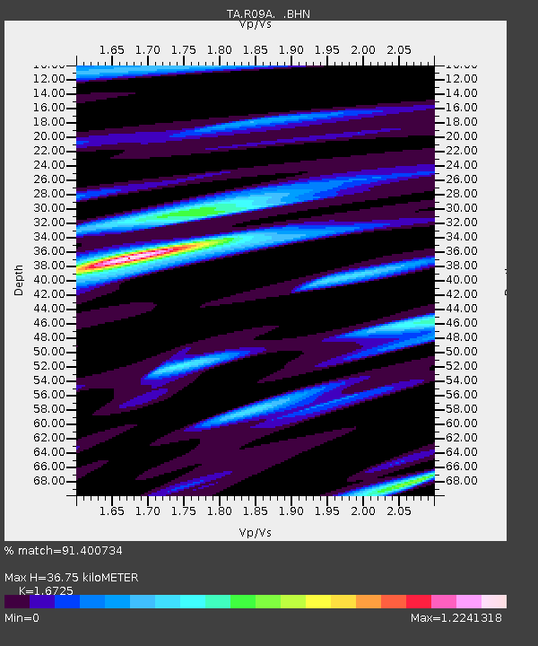
| Estimated Moho Depth: |
36.75 km |
| Estimated Crust Vp/Vs: |
1.67 |
| Assumed Crust Vp: |
6.276 km/s |
| Estimated Crust Vs: |
3.752 km/s |
| Estimated Crust Poisson's Ratio: |
0.22 |
|
| Radial Match: |
91.400734 % |
| Radial Bump: |
373 |
| Transverse Match: |
80.16439 % |
| Transverse Bump: |
400 |
| SOD ConfigId: |
2665 |
| Insert Time: |
2010-03-07 04:32:50.164 +0000 |
| GWidth: |
2.5 |
| Max Bumps: |
400 |
| Tol: |
0.001 |
|
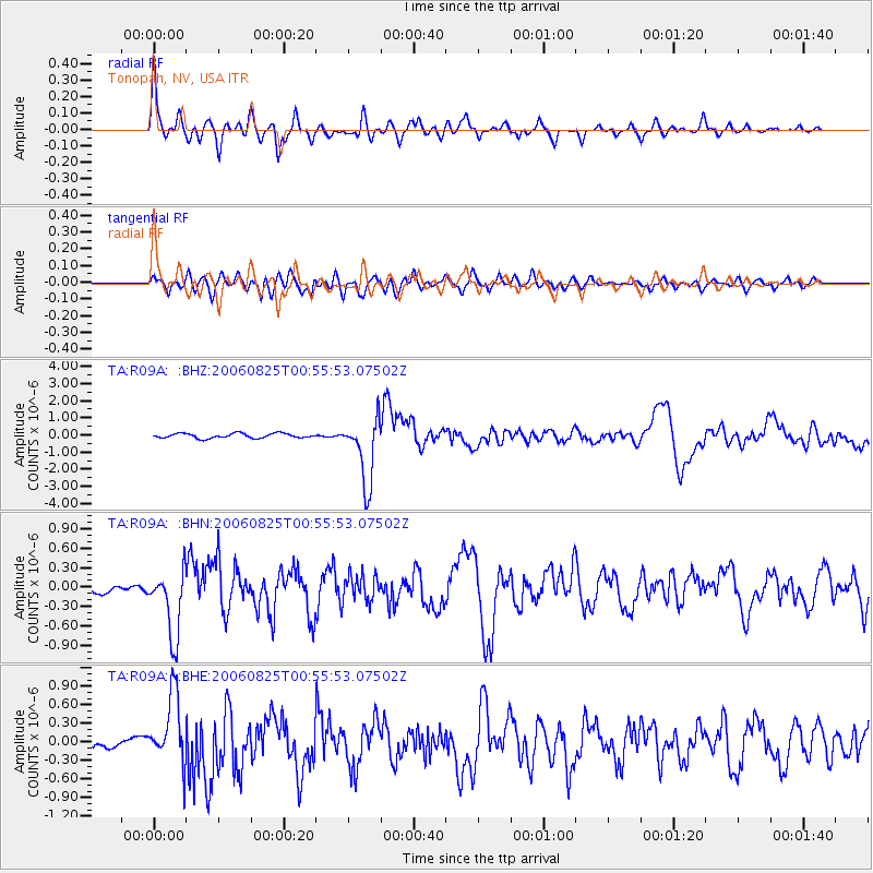
Signal To Noise
| Channel | StoN | STA | LTA |
| TA:R09A: :BHN:20060825T00:55:53.07502Z | 5.6040244 | 5.16954E-7 | 9.224693E-8 |
| TA:R09A: :BHE:20060825T00:55:53.07502Z | 8.234776 | 5.613556E-7 | 6.81689E-8 |
| TA:R09A: :BHZ:20060825T00:55:53.07502Z | 14.133351 | 1.9211352E-6 | 1.359292E-7 |
| Arrivals |
| Ps | 4.1 SECOND |
| PpPs | 15 SECOND |
| PsPs/PpSs | 19 SECOND |


