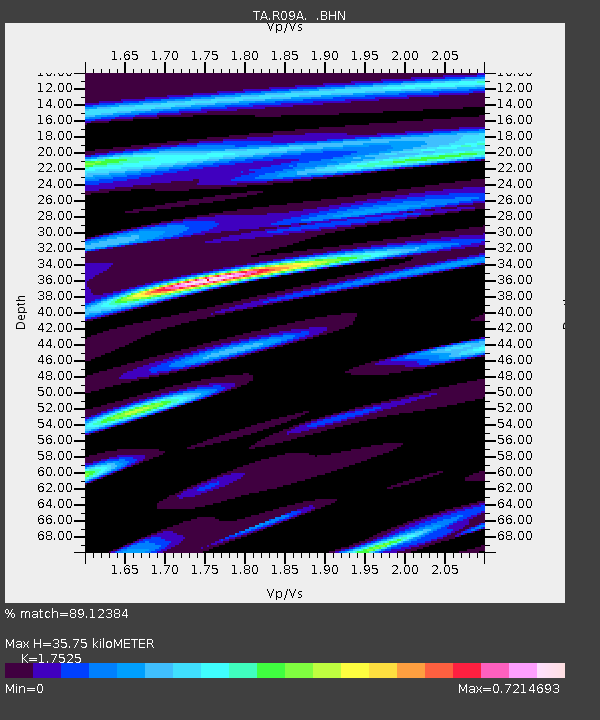
R09A Tonopah, NV, USA - Earthquake Result Viewer
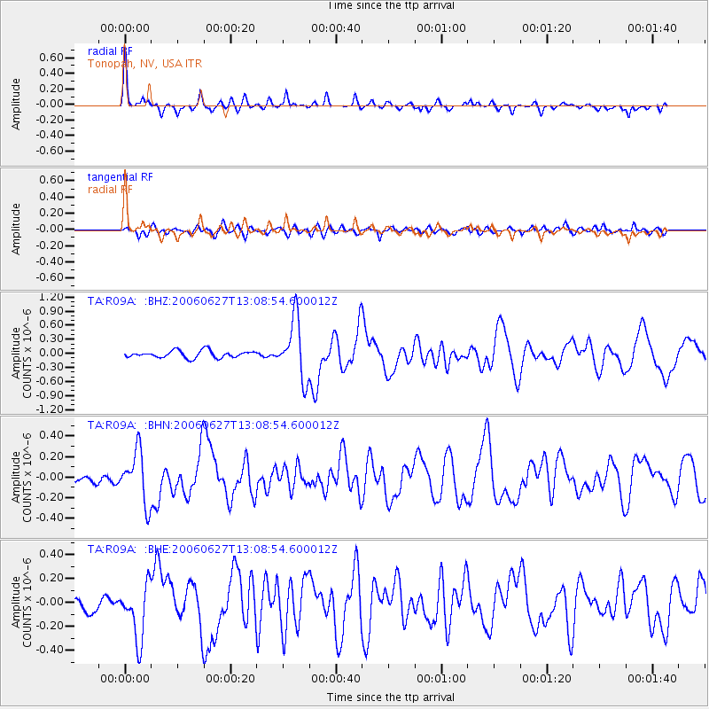
Earthquake location: Off Coast Of Chiapas, Mexico
Earthquake latitude/longitude: 15.0/-94.2
Earthquake time(UTC): 2006/06/27 (178) 13:03:12 GMT
Earthquake Depth: 29 km
Earthquake Magnitude: 5.4 MB, 5.5 MS, 5.8 MW, 5.8 MW
Earthquake Catalog/Contributor: WHDF/NEIC
Network: TA USArray Transportable Network (new EarthScope stations)
Station: R09A Tonopah, NV, USA
Lat/Lon: 38.24 N/117.07 W
Elevation: 1759 m
Distance: 30.8 deg
Az: 323.214 deg
Baz: 132.691 deg
Ray Param: 0.07922111
Estimated Moho Depth: 35.75 km
Estimated Crust Vp/Vs: 1.75
Assumed Crust Vp: 6.276 km/s
Estimated Crust Vs: 3.581 km/s
Estimated Crust Poisson's Ratio: 0.26
Radial Match: 89.12384 %
Radial Bump: 289
Transverse Match: 66.689064 %
Transverse Bump: 400
SOD ConfigId: 2665
Insert Time: 2010-03-07 04:32:55.832 +0000
GWidth: 2.5
Max Bumps: 400
Tol: 0.001

Signal To Noise

ChannelStoNSTALTA
TA:R09A: :BHN:20060627T13:08:54.600012Z5.95245082.5281093E-74.247174E-8
TA:R09A: :BHE:20060627T13:08:54.600012Z5.30308682.3159943E-74.367257E-8
TA:R09A: :BHZ:20060627T13:08:54.600012Z8.4383876.365469E-77.543466E-8
Arrivals
Ps4.6 SECOND
PpPs15 SECOND
PsPs/PpSs19 SECOND