You are here: Home > Network List > TA - USArray Transportable Network (new EarthScope stations) Stations List
> Station R09A Tonopah, NV, USA > Earthquake Result Viewer
R09A Tonopah, NV, USA - Earthquake Result Viewer
| Earthquake location: |
South Of Fiji Islands |
| Earthquake latitude/longitude: |
-25.8/179.5 |
| Earthquake time(UTC): |
2007/10/16 (289) 21:05:43 GMT |
| Earthquake Depth: |
509 km |
| Earthquake Magnitude: |
6.2 MB, 6.6 MW, 6.5 MW |
| Earthquake Catalog/Contributor: |
WHDF/NEIC |
|
| Network: |
TA USArray Transportable Network (new EarthScope stations) |
| Station: |
R09A Tonopah, NV, USA |
| Lat/Lon: |
38.24 N/117.07 W |
| Elevation: |
1759 m |
|
| Distance: |
87.1 deg |
| Az: |
44.831 deg |
| Baz: |
233.829 deg |
| Ray Param: |
0.042193875 |
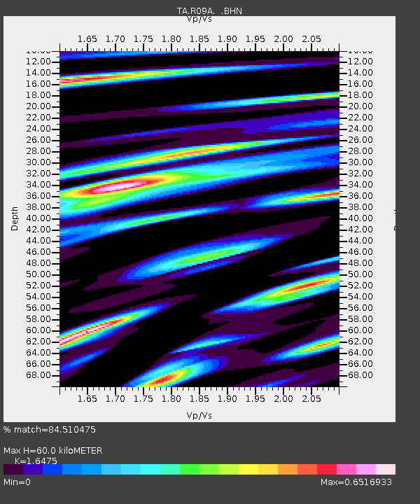
| Estimated Moho Depth: |
60.0 km |
| Estimated Crust Vp/Vs: |
1.65 |
| Assumed Crust Vp: |
6.276 km/s |
| Estimated Crust Vs: |
3.809 km/s |
| Estimated Crust Poisson's Ratio: |
0.21 |
|
| Radial Match: |
84.510475 % |
| Radial Bump: |
366 |
| Transverse Match: |
79.021164 % |
| Transverse Bump: |
372 |
| SOD ConfigId: |
2564 |
| Insert Time: |
2010-03-07 04:33:03.336 +0000 |
| GWidth: |
2.5 |
| Max Bumps: |
400 |
| Tol: |
0.001 |
|
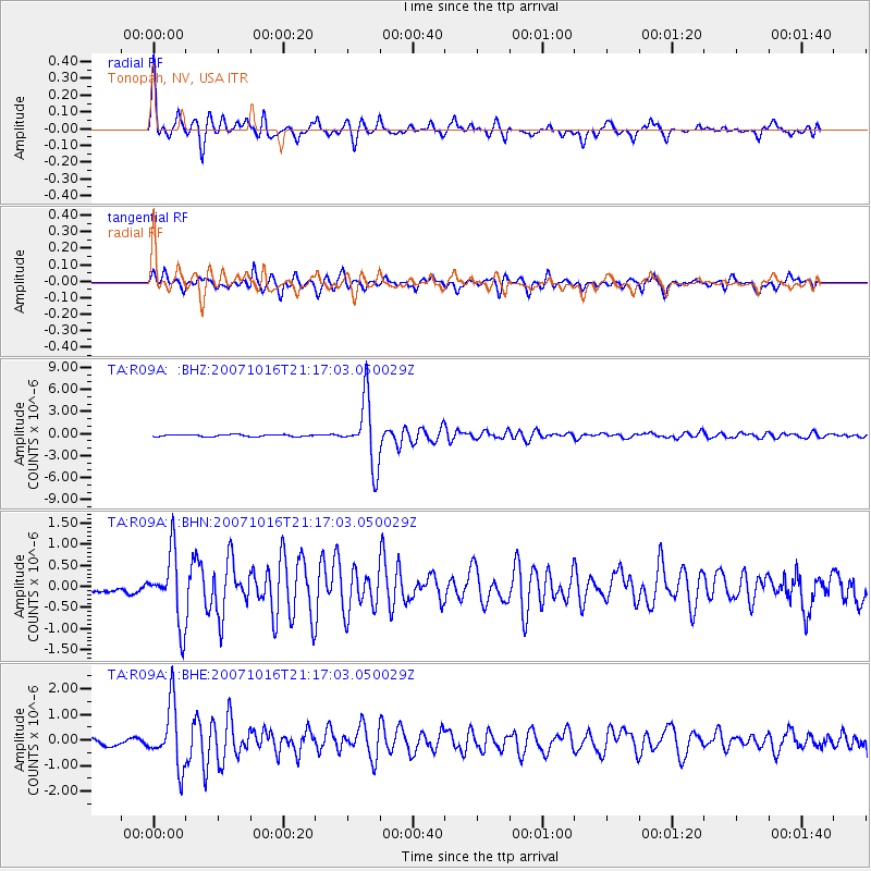
Signal To Noise
| Channel | StoN | STA | LTA |
| TA:R09A: :BHN:20071016T21:17:03.050029Z | 6.8254967 | 8.1671226E-7 | 1.196561E-7 |
| TA:R09A: :BHE:20071016T21:17:03.050029Z | 9.28204 | 1.1959853E-6 | 1.2884941E-7 |
| TA:R09A: :BHZ:20071016T21:17:03.050029Z | 33.531887 | 4.391984E-6 | 1.3097933E-7 |
| Arrivals |
| Ps | 6.3 SECOND |
| PpPs | 25 SECOND |
| PsPs/PpSs | 31 SECOND |


