You are here: Home > Network List > TA - USArray Transportable Network (new EarthScope stations) Stations List
> Station R09A Tonopah, NV, USA > Earthquake Result Viewer
R09A Tonopah, NV, USA - Earthquake Result Viewer
| Earthquake location: |
Kuril Islands |
| Earthquake latitude/longitude: |
45.8/150.1 |
| Earthquake time(UTC): |
2007/09/03 (246) 16:14:53 GMT |
| Earthquake Depth: |
94 km |
| Earthquake Magnitude: |
6.3 MB, 6.2 MW, 6.2 ME |
| Earthquake Catalog/Contributor: |
WHDF/NEIC |
|
| Network: |
TA USArray Transportable Network (new EarthScope stations) |
| Station: |
R09A Tonopah, NV, USA |
| Lat/Lon: |
38.24 N/117.07 W |
| Elevation: |
1759 m |
|
| Distance: |
65.6 deg |
| Az: |
59.725 deg |
| Baz: |
309.937 deg |
| Ray Param: |
0.05792305 |
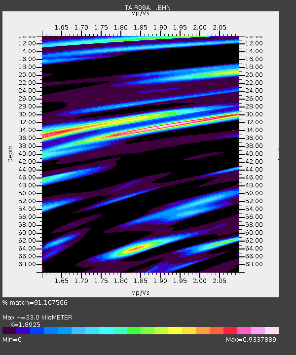
| Estimated Moho Depth: |
33.0 km |
| Estimated Crust Vp/Vs: |
1.89 |
| Assumed Crust Vp: |
6.276 km/s |
| Estimated Crust Vs: |
3.316 km/s |
| Estimated Crust Poisson's Ratio: |
0.31 |
|
| Radial Match: |
91.107506 % |
| Radial Bump: |
400 |
| Transverse Match: |
83.15651 % |
| Transverse Bump: |
400 |
| SOD ConfigId: |
2564 |
| Insert Time: |
2010-03-07 04:33:11.811 +0000 |
| GWidth: |
2.5 |
| Max Bumps: |
400 |
| Tol: |
0.001 |
|
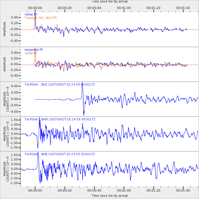
Signal To Noise
| Channel | StoN | STA | LTA |
| TA:R09A: :BHN:20070903T16:24:56.650017Z | 12.515073 | 7.5616845E-7 | 6.042062E-8 |
| TA:R09A: :BHE:20070903T16:24:56.650017Z | 8.83494 | 8.683806E-7 | 9.828936E-8 |
| TA:R09A: :BHZ:20070903T16:24:56.650017Z | 25.89696 | 2.3934062E-6 | 9.242035E-8 |
| Arrivals |
| Ps | 4.9 SECOND |
| PpPs | 15 SECOND |
| PsPs/PpSs | 20 SECOND |


