You are here: Home > Network List > TA - USArray Transportable Network (new EarthScope stations) Stations List
> Station R09A Tonopah, NV, USA > Earthquake Result Viewer
R09A Tonopah, NV, USA - Earthquake Result Viewer
| Earthquake location: |
Komandorskiye Ostrova Region |
| Earthquake latitude/longitude: |
53.6/169.7 |
| Earthquake time(UTC): |
2007/07/29 (210) 04:54:36 GMT |
| Earthquake Depth: |
26 km |
| Earthquake Magnitude: |
6.0 MB, 5.5 MS, 5.9 MW, 5.8 MW |
| Earthquake Catalog/Contributor: |
WHDF/NEIC |
|
| Network: |
TA USArray Transportable Network (new EarthScope stations) |
| Station: |
R09A Tonopah, NV, USA |
| Lat/Lon: |
38.24 N/117.07 W |
| Elevation: |
1759 m |
|
| Distance: |
50.9 deg |
| Az: |
76.254 deg |
| Baz: |
312.736 deg |
| Ray Param: |
0.067703225 |
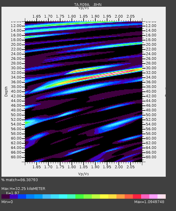
| Estimated Moho Depth: |
32.25 km |
| Estimated Crust Vp/Vs: |
1.97 |
| Assumed Crust Vp: |
6.276 km/s |
| Estimated Crust Vs: |
3.186 km/s |
| Estimated Crust Poisson's Ratio: |
0.33 |
|
| Radial Match: |
86.38793 % |
| Radial Bump: |
400 |
| Transverse Match: |
74.71707 % |
| Transverse Bump: |
400 |
| SOD ConfigId: |
2564 |
| Insert Time: |
2010-03-07 04:33:20.468 +0000 |
| GWidth: |
2.5 |
| Max Bumps: |
400 |
| Tol: |
0.001 |
|
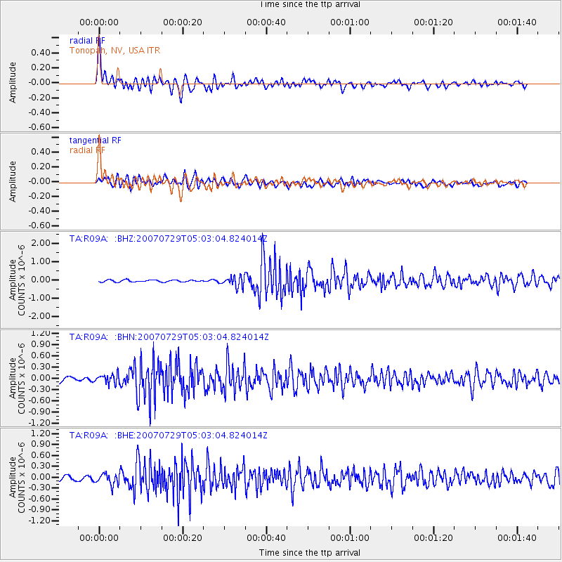
Signal To Noise
| Channel | StoN | STA | LTA |
| TA:R09A: :BHN:20070729T05:03:04.824014Z | 1.5219766 | 1.17870776E-7 | 7.7445854E-8 |
| TA:R09A: :BHE:20070729T05:03:04.824014Z | 3.0607066 | 1.5079898E-7 | 4.926934E-8 |
| TA:R09A: :BHZ:20070729T05:03:04.824014Z | 5.252416 | 2.7880432E-7 | 5.308116E-8 |
| Arrivals |
| Ps | 5.2 SECOND |
| PpPs | 15 SECOND |
| PsPs/PpSs | 20 SECOND |


