You are here: Home > Network List > TA - USArray Transportable Network (new EarthScope stations) Stations List
> Station R09A Tonopah, NV, USA > Earthquake Result Viewer
R09A Tonopah, NV, USA - Earthquake Result Viewer
| Earthquake location: |
Southeast Of Loyalty Islands |
| Earthquake latitude/longitude: |
-21.5/170.9 |
| Earthquake time(UTC): |
2007/07/27 (208) 14:46:26 GMT |
| Earthquake Depth: |
10 km |
| Earthquake Magnitude: |
6.0 MB, 6.0 MS, 6.1 MW, 6.1 MW |
| Earthquake Catalog/Contributor: |
WHDF/NEIC |
|
| Network: |
TA USArray Transportable Network (new EarthScope stations) |
| Station: |
R09A Tonopah, NV, USA |
| Lat/Lon: |
38.24 N/117.07 W |
| Elevation: |
1759 m |
|
| Distance: |
89.9 deg |
| Az: |
48.492 deg |
| Baz: |
242.359 deg |
| Ray Param: |
0.04171529 |
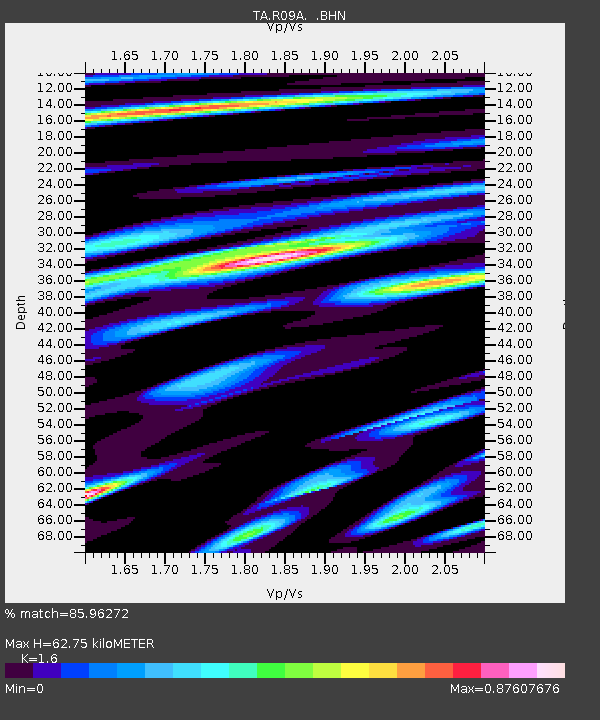
| Estimated Moho Depth: |
62.75 km |
| Estimated Crust Vp/Vs: |
1.60 |
| Assumed Crust Vp: |
6.276 km/s |
| Estimated Crust Vs: |
3.922 km/s |
| Estimated Crust Poisson's Ratio: |
0.18 |
|
| Radial Match: |
85.96272 % |
| Radial Bump: |
400 |
| Transverse Match: |
80.524635 % |
| Transverse Bump: |
400 |
| SOD ConfigId: |
2564 |
| Insert Time: |
2010-03-07 04:33:22.799 +0000 |
| GWidth: |
2.5 |
| Max Bumps: |
400 |
| Tol: |
0.001 |
|
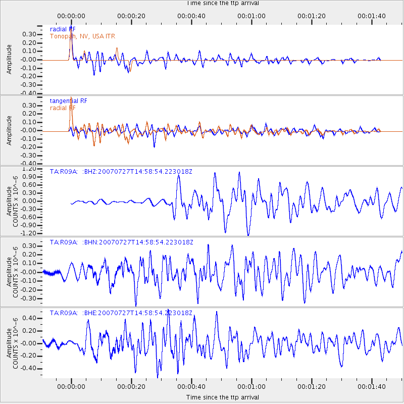
Signal To Noise
| Channel | StoN | STA | LTA |
| TA:R09A: :BHN:20070727T14:58:54.223018Z | 1.8543229 | 7.19379E-8 | 3.87947E-8 |
| TA:R09A: :BHE:20070727T14:58:54.223018Z | 1.769176 | 7.3537606E-8 | 4.1566018E-8 |
| TA:R09A: :BHZ:20070727T14:58:54.223018Z | 5.0106945 | 2.1843027E-7 | 4.3592813E-8 |
| Arrivals |
| Ps | 6.1 SECOND |
| PpPs | 25 SECOND |
| PsPs/PpSs | 32 SECOND |


