You are here: Home > Network List > IU - Global Seismograph Network (GSN - IRIS/USGS) Stations List
> Station XMAS Kiritimati Island, Republic of Kiribati > Earthquake Result Viewer
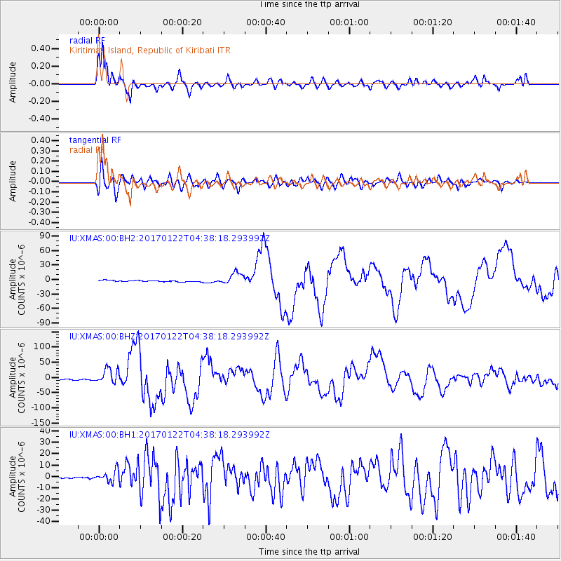
XMAS Kiritimati Island, Republic of Kiribati - Earthquake Result Viewer
*The percent match for this event was below the threshold and hence no stack was calculated.
| Earthquake location: |
Solomon Islands |
| Earthquake latitude/longitude: |
-6.2/155.1 |
| Earthquake time(UTC): |
2017/01/22 (022) 04:30:23 GMT |
| Earthquake Depth: |
136 km |
| Earthquake Magnitude: |
7.9 mww |
| Earthquake Catalog/Contributor: |
NEIC PDE/us |
|
| Network: |
IU Global Seismograph Network (GSN - IRIS/USGS) |
| Station: |
XMAS Kiritimati Island, Republic of Kiribati |
| Lat/Lon: |
2.04 N/157.45 W |
| Elevation: |
20 m |
|
| Distance: |
48.1 deg |
| Az: |
81.658 deg |
| Baz: |
259.834 deg |
| Ray Param: |
$rayparam |
*The percent match for this event was below the threshold and hence was not used in the summary stack. |
|
| Radial Match: |
95.31142 % |
| Radial Bump: |
381 |
| Transverse Match: |
86.33946 % |
| Transverse Bump: |
400 |
| SOD ConfigId: |
1943534 |
| Insert Time: |
2017-02-05 04:32:40.557 +0000 |
| GWidth: |
2.5 |
| Max Bumps: |
400 |
| Tol: |
0.001 |
|
Signal To Noise
| Channel | StoN | STA | LTA |
| IU:XMAS:00:BHZ:20170122T04:38:18.293992Z | 9.039745 | 2.4930869E-5 | 2.7579172E-6 |
| IU:XMAS:00:BH1:20170122T04:38:18.293992Z | 3.8451781 | 5.109467E-6 | 1.3287986E-6 |
| IU:XMAS:00:BH2:20170122T04:38:18.293992Z | 9.462797 | 1.2916634E-5 | 1.364991E-6 |
| Arrivals |
| Ps | |
| PpPs | |
| PsPs/PpSs | |


