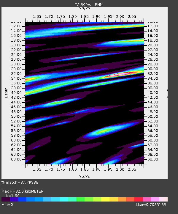
R09A Tonopah, NV, USA - Earthquake Result Viewer
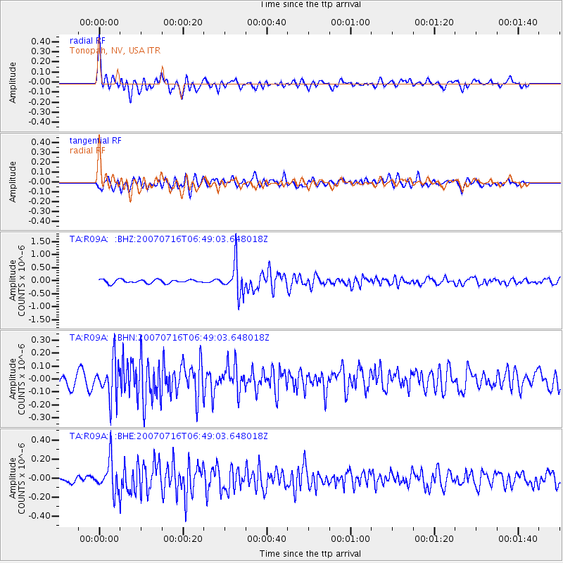
Earthquake location: Near West Coast Of Honshu, Japan
Earthquake latitude/longitude: 37.5/138.5
Earthquake time(UTC): 2007/07/16 (197) 06:37:40 GMT
Earthquake Depth: 15 km
Earthquake Magnitude: 5.7 MB, 5.1 MS, 5.7 MW, 5.6 MW
Earthquake Catalog/Contributor: WHDF/NEIC
Network: TA USArray Transportable Network (new EarthScope stations)
Station: R09A Tonopah, NV, USA
Lat/Lon: 38.24 N/117.07 W
Elevation: 1759 m
Distance: 77.5 deg
Az: 51.367 deg
Baz: 307.912 deg
Ray Param: 0.05030413
Estimated Moho Depth: 32.0 km
Estimated Crust Vp/Vs: 1.99
Assumed Crust Vp: 6.276 km/s
Estimated Crust Vs: 3.154 km/s
Estimated Crust Poisson's Ratio: 0.33
Radial Match: 87.79388 %
Radial Bump: 400
Transverse Match: 79.11818 %
Transverse Bump: 400
SOD ConfigId: 2564
Insert Time: 2010-03-07 04:33:27.522 +0000
GWidth: 2.5
Max Bumps: 400
Tol: 0.001

Signal To Noise

ChannelStoNSTALTA
TA:R09A: :BHN:20070716T06:49:03.648018Z3.78984831.4799667E-73.9050818E-8
TA:R09A: :BHE:20070716T06:49:03.648018Z5.5471971.7250274E-73.1097283E-8
TA:R09A: :BHZ:20070716T06:49:03.648018Z8.7957236.054025E-76.882919E-8
Arrivals
Ps5.2 SECOND
PpPs15 SECOND
PsPs/PpSs20 SECOND