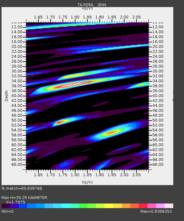
R09A Tonopah, NV, USA - Earthquake Result Viewer
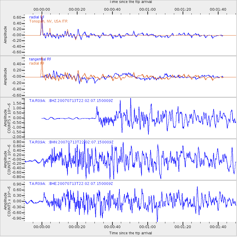
Earthquake location: Andreanof Islands, Aleutian Is.
Earthquake latitude/longitude: 51.8/-176.3
Earthquake time(UTC): 2007/07/13 (194) 21:54:43 GMT
Earthquake Depth: 35 km
Earthquake Magnitude: 5.7 MB, 5.6 MS, 6.0 MW, 5.9 MW
Earthquake Catalog/Contributor: WHDF/NEIC
Network: TA USArray Transportable Network (new EarthScope stations)
Station: R09A Tonopah, NV, USA
Lat/Lon: 38.24 N/117.07 W
Elevation: 1759 m
Distance: 42.8 deg
Az: 84.402 deg
Baz: 308.356 deg
Ray Param: 0.07287367
Estimated Moho Depth: 35.25 km
Estimated Crust Vp/Vs: 1.79
Assumed Crust Vp: 6.276 km/s
Estimated Crust Vs: 3.511 km/s
Estimated Crust Poisson's Ratio: 0.27
Radial Match: 85.939766 %
Radial Bump: 400
Transverse Match: 75.47282 %
Transverse Bump: 400
SOD ConfigId: 2564
Insert Time: 2010-03-07 04:33:31.564 +0000
GWidth: 2.5
Max Bumps: 400
Tol: 0.001

Signal To Noise

ChannelStoNSTALTA
TA:R09A: :BHN:20070713T22:02:07.150009Z1.4381531.1661013E-78.108326E-8
TA:R09A: :BHE:20070713T22:02:07.150009Z3.34293481.8416047E-75.508946E-8
TA:R09A: :BHZ:20070713T22:02:07.150009Z9.2373254.7216022E-75.111439E-8
Arrivals
Ps4.7 SECOND
PpPs15 SECOND
PsPs/PpSs19 SECOND