You are here: Home > Network List > TA - USArray Transportable Network (new EarthScope stations) Stations List
> Station R09A Tonopah, NV, USA > Earthquake Result Viewer
R09A Tonopah, NV, USA - Earthquake Result Viewer
| Earthquake location: |
Solomon Islands |
| Earthquake latitude/longitude: |
-8.5/157.0 |
| Earthquake time(UTC): |
2007/04/01 (091) 20:39:56 GMT |
| Earthquake Depth: |
10 km |
| Earthquake Magnitude: |
6.8 MB, 7.9 MS, 8.1 MW, 7.7 ME |
| Earthquake Catalog/Contributor: |
WHDF/NEIC |
|
| Network: |
TA USArray Transportable Network (new EarthScope stations) |
| Station: |
R09A Tonopah, NV, USA |
| Lat/Lon: |
38.24 N/117.07 W |
| Elevation: |
1759 m |
|
| Distance: |
92.0 deg |
| Az: |
51.801 deg |
| Baz: |
260.854 deg |
| Ray Param: |
0.04153083 |
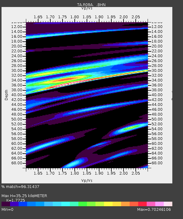
| Estimated Moho Depth: |
35.25 km |
| Estimated Crust Vp/Vs: |
1.77 |
| Assumed Crust Vp: |
6.276 km/s |
| Estimated Crust Vs: |
3.541 km/s |
| Estimated Crust Poisson's Ratio: |
0.27 |
|
| Radial Match: |
96.31437 % |
| Radial Bump: |
377 |
| Transverse Match: |
85.26669 % |
| Transverse Bump: |
400 |
| SOD ConfigId: |
2564 |
| Insert Time: |
2010-03-07 04:33:39.529 +0000 |
| GWidth: |
2.5 |
| Max Bumps: |
400 |
| Tol: |
0.001 |
|
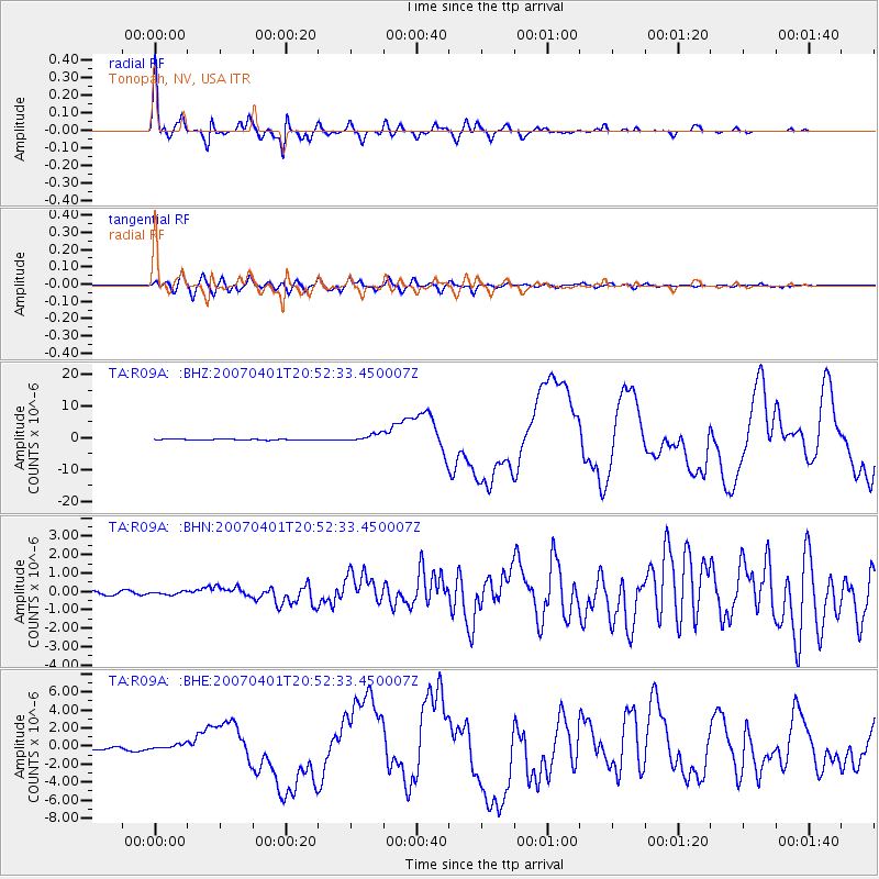
Signal To Noise
| Channel | StoN | STA | LTA |
| TA:R09A: :BHN:20070401T20:52:33.450007Z | 0.9381472 | 9.9046396E-8 | 1.055766E-7 |
| TA:R09A: :BHE:20070401T20:52:33.450007Z | 3.1545632 | 3.190183E-7 | 1.0112915E-7 |
| TA:R09A: :BHZ:20070401T20:52:33.450007Z | 7.9864197 | 1.2221743E-6 | 1.5303156E-7 |
| Arrivals |
| Ps | 4.4 SECOND |
| PpPs | 15 SECOND |
| PsPs/PpSs | 20 SECOND |


