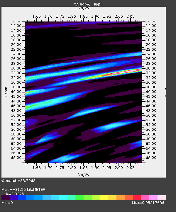
R09A Tonopah, NV, USA - Earthquake Result Viewer
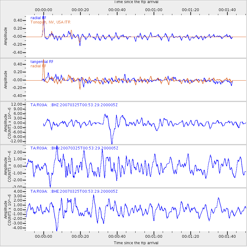
Earthquake location: Near West Coast Of Honshu, Japan
Earthquake latitude/longitude: 37.3/136.6
Earthquake time(UTC): 2007/03/25 (084) 00:41:57 GMT
Earthquake Depth: 8.0 km
Earthquake Magnitude: 6.1 MB, 6.8 MS, 6.7 MW, 6.6 MW
Earthquake Catalog/Contributor: WHDF/NEIC
Network: TA USArray Transportable Network (new EarthScope stations)
Station: R09A Tonopah, NV, USA
Lat/Lon: 38.24 N/117.07 W
Elevation: 1759 m
Distance: 78.7 deg
Az: 50.402 deg
Baz: 308.746 deg
Ray Param: 0.049456112
Estimated Moho Depth: 31.25 km
Estimated Crust Vp/Vs: 2.03
Assumed Crust Vp: 6.276 km/s
Estimated Crust Vs: 3.095 km/s
Estimated Crust Poisson's Ratio: 0.34
Radial Match: 83.70684 %
Radial Bump: 399
Transverse Match: 71.6789 %
Transverse Bump: 400
SOD ConfigId: 2564
Insert Time: 2010-03-07 04:33:41.139 +0000
GWidth: 2.5
Max Bumps: 400
Tol: 0.001

Signal To Noise

ChannelStoNSTALTA
TA:R09A: :BHN:20070325T00:53:29.200005Z2.27439331.261819E-65.547937E-7
TA:R09A: :BHE:20070325T00:53:29.200005Z1.06979137.828067E-77.3173777E-7
TA:R09A: :BHZ:20070325T00:53:29.200005Z2.17172482.8994912E-61.3351098E-6
Arrivals
Ps5.2 SECOND
PpPs15 SECOND
PsPs/PpSs20 SECOND