You are here: Home > Network List > LB - Leo Brady Network Stations List
> Station TPH Tonopah, Nevada, USA > Earthquake Result Viewer
TPH Tonopah, Nevada, USA - Earthquake Result Viewer
| Earthquake location: |
Solomon Islands |
| Earthquake latitude/longitude: |
-6.2/155.1 |
| Earthquake time(UTC): |
2017/01/22 (022) 04:30:23 GMT |
| Earthquake Depth: |
136 km |
| Earthquake Magnitude: |
7.9 mww |
| Earthquake Catalog/Contributor: |
NEIC PDE/us |
|
| Network: |
LB Leo Brady Network |
| Station: |
TPH Tonopah, Nevada, USA |
| Lat/Lon: |
38.08 N/117.22 W |
| Elevation: |
1883 m |
|
| Distance: |
91.9 deg |
| Az: |
52.092 deg |
| Baz: |
263.69 deg |
| Ray Param: |
0.041473642 |
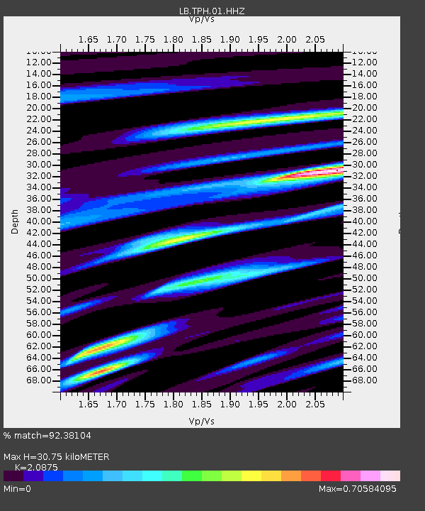
| Estimated Moho Depth: |
30.75 km |
| Estimated Crust Vp/Vs: |
2.09 |
| Assumed Crust Vp: |
6.276 km/s |
| Estimated Crust Vs: |
3.006 km/s |
| Estimated Crust Poisson's Ratio: |
0.35 |
|
| Radial Match: |
92.38104 % |
| Radial Bump: |
400 |
| Transverse Match: |
81.56988 % |
| Transverse Bump: |
400 |
| SOD ConfigId: |
1943534 |
| Insert Time: |
2017-02-05 04:32:57.594 +0000 |
| GWidth: |
2.5 |
| Max Bumps: |
400 |
| Tol: |
0.001 |
|

Signal To Noise
| Channel | StoN | STA | LTA |
| LB:TPH:01:HHZ:20170122T04:42:44.978013Z | 6.171465 | 2.4370835E-5 | 3.9489546E-6 |
| LB:TPH:01:HHN:20170122T04:42:44.978013Z | 1.2006006 | 1.8203666E-6 | 1.5162132E-6 |
| LB:TPH:01:HHE:20170122T04:42:44.978013Z | 0.95363355 | 4.4294175E-6 | 4.6447794E-6 |
| Arrivals |
| Ps | 5.4 SECOND |
| PpPs | 15 SECOND |
| PsPs/PpSs | 20 SECOND |


