You are here: Home > Network List > TS - TERRAscope (Southern California Seismic Network) Stations List
> Station MLAC Mammoth Lakes, California, USA > Earthquake Result Viewer
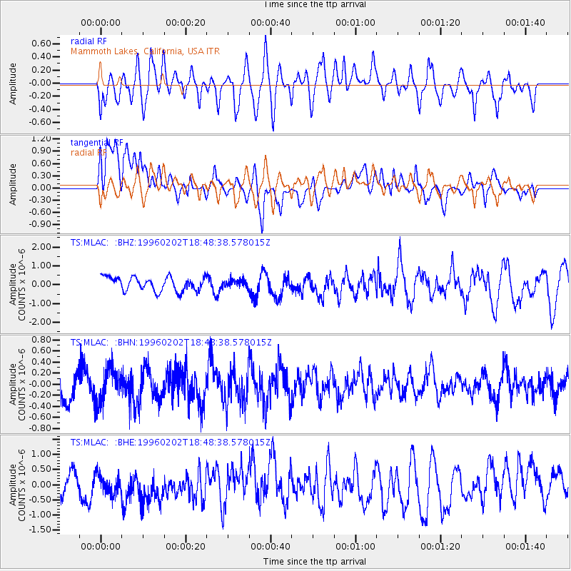
MLAC Mammoth Lakes, California, USA - Earthquake Result Viewer
*The percent match for this event was below the threshold and hence no stack was calculated.
| Earthquake location: |
W. Caroline Islands, Micronesia |
| Earthquake latitude/longitude: |
11.4/141.6 |
| Earthquake time(UTC): |
1996/02/02 (033) 18:36:11 GMT |
| Earthquake Depth: |
33 km |
| Earthquake Magnitude: |
5.5 MS, 5.3 MB, 5.7 UNKNOWN, 5.7 MW |
| Earthquake Catalog/Contributor: |
WHDF/NEIC |
|
| Network: |
TS TERRAscope (Southern California Seismic Network) |
| Station: |
MLAC Mammoth Lakes, California, USA |
| Lat/Lon: |
37.63 N/118.83 W |
| Elevation: |
2170 m |
|
| Distance: |
90.5 deg |
| Az: |
51.536 deg |
| Baz: |
284.785 deg |
| Ray Param: |
$rayparam |
*The percent match for this event was below the threshold and hence was not used in the summary stack. |
|
| Radial Match: |
67.49011 % |
| Radial Bump: |
400 |
| Transverse Match: |
60.445057 % |
| Transverse Bump: |
400 |
| SOD ConfigId: |
4480 |
| Insert Time: |
2010-02-26 14:29:46.597 +0000 |
| GWidth: |
2.5 |
| Max Bumps: |
400 |
| Tol: |
0.001 |
|
Signal To Noise
| Channel | StoN | STA | LTA |
| TS:MLAC: :BHN:19960202T18:48:38.578015Z | 0.9655693 | 3.0208102E-7 | 3.1285276E-7 |
| TS:MLAC: :BHE:19960202T18:48:38.578015Z | 0.63426304 | 4.803408E-7 | 7.573212E-7 |
| TS:MLAC: :BHZ:19960202T18:48:38.578015Z | 0.55921215 | 2.040041E-7 | 3.6480628E-7 |
| Arrivals |
| Ps | |
| PpPs | |
| PsPs/PpSs | |


