You are here: Home > Network List > TJ - Tajikistan National Seismic Network Stations List
> Station CHGR Chuyangaron, Tajikistan > Earthquake Result Viewer
CHGR Chuyangaron, Tajikistan - Earthquake Result Viewer
| Earthquake location: |
Southwest Indian Ridge |
| Earthquake latitude/longitude: |
-33.8/56.2 |
| Earthquake time(UTC): |
2019/09/24 (267) 21:19:47 GMT |
| Earthquake Depth: |
10 km |
| Earthquake Magnitude: |
6.1 Mww |
| Earthquake Catalog/Contributor: |
NEIC PDE/us |
|
| Network: |
TJ Tajikistan National Seismic Network |
| Station: |
CHGR Chuyangaron, Tajikistan |
| Lat/Lon: |
38.66 N/69.16 E |
| Elevation: |
1049 m |
|
| Distance: |
73.1 deg |
| Az: |
10.533 deg |
| Baz: |
191.209 deg |
| Ray Param: |
0.05322816 |
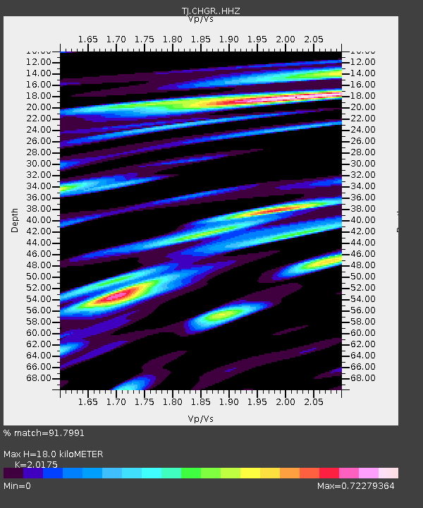
| Estimated Moho Depth: |
18.0 km |
| Estimated Crust Vp/Vs: |
2.02 |
| Assumed Crust Vp: |
6.483 km/s |
| Estimated Crust Vs: |
3.213 km/s |
| Estimated Crust Poisson's Ratio: |
0.34 |
|
| Radial Match: |
91.7991 % |
| Radial Bump: |
398 |
| Transverse Match: |
84.59698 % |
| Transverse Bump: |
400 |
| SOD ConfigId: |
19053131 |
| Insert Time: |
2019-10-08 21:23:36.714 +0000 |
| GWidth: |
2.5 |
| Max Bumps: |
400 |
| Tol: |
0.001 |
|

Signal To Noise
| Channel | StoN | STA | LTA |
| TJ:CHGR: :HHZ:20190924T21:30:46.789979Z | 15.979318 | 1.6597772E-6 | 1.0387034E-7 |
| TJ:CHGR: :HHN:20190924T21:30:46.789979Z | 5.5692105 | 6.0918916E-7 | 1.0938519E-7 |
| TJ:CHGR: :HHE:20190924T21:30:46.789979Z | 1.6414196 | 1.4638353E-7 | 8.918105E-8 |
| Arrivals |
| Ps | 2.9 SECOND |
| PpPs | 8.1 SECOND |
| PsPs/PpSs | 11 SECOND |


