You are here: Home > Network List > TS - TERRAscope (Southern California Seismic Network) Stations List
> Station MLAC Mammoth Lakes, California, USA > Earthquake Result Viewer
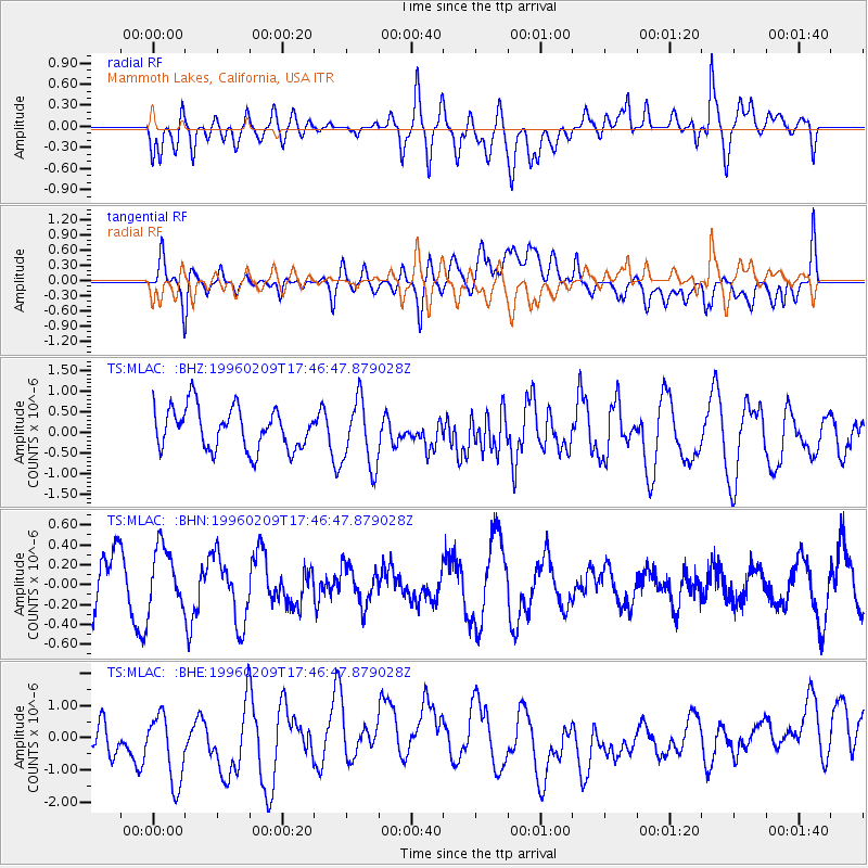
MLAC Mammoth Lakes, California, USA - Earthquake Result Viewer
*The percent match for this event was below the threshold and hence no stack was calculated.
| Earthquake location: |
Eastern New Guinea Reg., P.N.G. |
| Earthquake latitude/longitude: |
-6.0/146.6 |
| Earthquake time(UTC): |
1996/02/09 (040) 17:33:52 GMT |
| Earthquake Depth: |
54 km |
| Earthquake Magnitude: |
5.6 MB, 5.8 MS, 6.0 UNKNOWN, 5.9 MW |
| Earthquake Catalog/Contributor: |
WHDF/NEIC |
|
| Network: |
TS TERRAscope (Southern California Seismic Network) |
| Station: |
MLAC Mammoth Lakes, California, USA |
| Lat/Lon: |
37.63 N/118.83 W |
| Elevation: |
2170 m |
|
| Distance: |
97.2 deg |
| Az: |
52.917 deg |
| Baz: |
268.009 deg |
| Ray Param: |
$rayparam |
*The percent match for this event was below the threshold and hence was not used in the summary stack. |
|
| Radial Match: |
52.656982 % |
| Radial Bump: |
400 |
| Transverse Match: |
56.600986 % |
| Transverse Bump: |
400 |
| SOD ConfigId: |
4480 |
| Insert Time: |
2010-02-26 14:29:50.161 +0000 |
| GWidth: |
2.5 |
| Max Bumps: |
400 |
| Tol: |
0.001 |
|
Signal To Noise
| Channel | StoN | STA | LTA |
| TS:MLAC: :BHN:19960209T17:46:47.879028Z | 0.9990841 | 3.070562E-7 | 3.0733767E-7 |
| TS:MLAC: :BHE:19960209T17:46:47.879028Z | 2.4908006 | 1.1787716E-6 | 4.732501E-7 |
| TS:MLAC: :BHZ:19960209T17:46:47.879028Z | 1.6271923 | 8.195275E-7 | 5.036452E-7 |
| Arrivals |
| Ps | |
| PpPs | |
| PsPs/PpSs | |


