You are here: Home > Network List > UU - University of Utah Regional Network Stations List
> Station PSUT Pine Spring, UT, USA > Earthquake Result Viewer
PSUT Pine Spring, UT, USA - Earthquake Result Viewer

| Earthquake location: |
Solomon Islands |
| Earthquake latitude/longitude: |
-6.2/155.1 |
| Earthquake time(UTC): |
2017/01/22 (022) 04:30:23 GMT |
| Earthquake Depth: |
136 km |
| Earthquake Magnitude: |
7.9 mww |
| Earthquake Catalog/Contributor: |
NEIC PDE/us |
|
| Network: |
UU University of Utah Regional Network |
| Station: |
PSUT Pine Spring, UT, USA |
| Lat/Lon: |
38.53 N/113.85 W |
| Elevation: |
1999 m |
|
| Distance: |
94.6 deg |
| Az: |
51.879 deg |
| Baz: |
265.782 deg |
| Ray Param: |
0.040895972 |
| Estimated Moho Depth: |
36.5 km |
| Estimated Crust Vp/Vs: |
1.72 |
| Assumed Crust Vp: |
6.276 km/s |
| Estimated Crust Vs: |
3.643 km/s |
| Estimated Crust Poisson's Ratio: |
0.25 |
|
| Radial Match: |
98.893456 % |
| Radial Bump: |
275 |
| Transverse Match: |
98.24197 % |
| Transverse Bump: |
357 |
| SOD ConfigId: |
1943534 |
| Insert Time: |
2017-02-05 04:34:02.951 +0000 |
| GWidth: |
2.5 |
| Max Bumps: |
400 |
| Tol: |
0.001 |
|
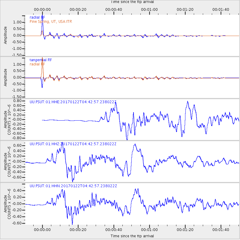
Signal To Noise
| Channel | StoN | STA | LTA |
| UU:PSUT:01:HHZ:20170122T04:42:57.238022Z | 3.8162165 | 5.6287796E-8 | 1.47496335E-8 |
| UU:PSUT:01:HHN:20170122T04:42:57.238022Z | 3.1525722 | 3.469277E-8 | 1.1004593E-8 |
| UU:PSUT:01:HHE:20170122T04:42:57.238022Z | 4.0686736 | 6.192413E-8 | 1.5219735E-8 |
| Arrivals |
| Ps | 4.3 SECOND |
| PpPs | 16 SECOND |
| PsPs/PpSs | 20 SECOND |


