You are here: Home > Network List > TA - USArray Transportable Network (new EarthScope stations) Stations List
> Station C16K Lisburne Hills, AK, USA > Earthquake Result Viewer
C16K Lisburne Hills, AK, USA - Earthquake Result Viewer
| Earthquake location: |
Seram, Indonesia |
| Earthquake latitude/longitude: |
-3.4/128.4 |
| Earthquake time(UTC): |
2019/09/25 (268) 23:46:46 GMT |
| Earthquake Depth: |
30 km |
| Earthquake Magnitude: |
6.5 Mww |
| Earthquake Catalog/Contributor: |
NEIC PDE/us |
|
| Network: |
TA USArray Transportable Network (new EarthScope stations) |
| Station: |
C16K Lisburne Hills, AK, USA |
| Lat/Lon: |
68.27 N/165.34 W |
| Elevation: |
102 m |
|
| Distance: |
84.6 deg |
| Az: |
20.022 deg |
| Baz: |
246.635 deg |
| Ray Param: |
0.045342077 |
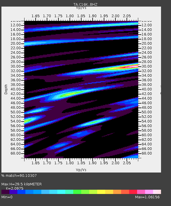
| Estimated Moho Depth: |
29.5 km |
| Estimated Crust Vp/Vs: |
2.10 |
| Assumed Crust Vp: |
5.906 km/s |
| Estimated Crust Vs: |
2.816 km/s |
| Estimated Crust Poisson's Ratio: |
0.35 |
|
| Radial Match: |
90.10307 % |
| Radial Bump: |
400 |
| Transverse Match: |
84.18766 % |
| Transverse Bump: |
400 |
| SOD ConfigId: |
19053131 |
| Insert Time: |
2019-10-09 23:51:17.585 +0000 |
| GWidth: |
2.5 |
| Max Bumps: |
400 |
| Tol: |
0.001 |
|
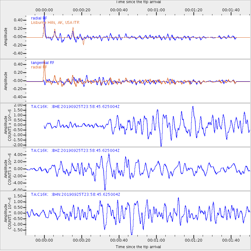
Signal To Noise
| Channel | StoN | STA | LTA |
| TA:C16K: :BHZ:20190925T23:58:45.625004Z | 3.5827973 | 5.8279664E-7 | 1.6266526E-7 |
| TA:C16K: :BHN:20190925T23:58:45.625004Z | 1.2288698 | 2.648219E-7 | 2.1550036E-7 |
| TA:C16K: :BHE:20190925T23:58:45.625004Z | 1.0868809 | 1.8798102E-7 | 1.7295456E-7 |
| Arrivals |
| Ps | 5.6 SECOND |
| PpPs | 15 SECOND |
| PsPs/PpSs | 21 SECOND |


