You are here: Home > Network List > TA - USArray Transportable Network (new EarthScope stations) Stations List
> Station A04A Lummi Island, Lummi Island, WA, USA > Earthquake Result Viewer
A04A Lummi Island, Lummi Island, WA, USA - Earthquake Result Viewer
| Earthquake location: |
Off East Coast Of Honshu, Japan |
| Earthquake latitude/longitude: |
38.1/144.9 |
| Earthquake time(UTC): |
2005/11/14 (318) 21:38:51 GMT |
| Earthquake Depth: |
11 km |
| Earthquake Magnitude: |
6.7 MB, 6.8 MS, 7.0 MW, 6.9 MW |
| Earthquake Catalog/Contributor: |
WHDF/NEIC |
|
| Network: |
TA USArray Transportable Network (new EarthScope stations) |
| Station: |
A04A Lummi Island, Lummi Island, WA, USA |
| Lat/Lon: |
48.72 N/122.71 W |
| Elevation: |
23 m |
|
| Distance: |
64.0 deg |
| Az: |
47.415 deg |
| Baz: |
298.711 deg |
| Ray Param: |
0.05921745 |
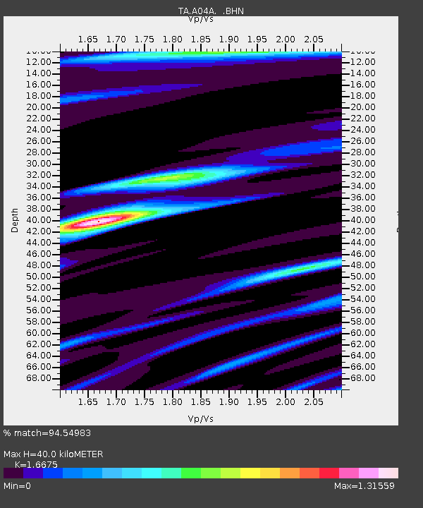
| Estimated Moho Depth: |
40.0 km |
| Estimated Crust Vp/Vs: |
1.67 |
| Assumed Crust Vp: |
6.566 km/s |
| Estimated Crust Vs: |
3.938 km/s |
| Estimated Crust Poisson's Ratio: |
0.22 |
|
| Radial Match: |
94.54983 % |
| Radial Bump: |
400 |
| Transverse Match: |
87.768524 % |
| Transverse Bump: |
400 |
| SOD ConfigId: |
2448 |
| Insert Time: |
2010-03-07 04:36:23.578 +0000 |
| GWidth: |
2.5 |
| Max Bumps: |
400 |
| Tol: |
0.001 |
|
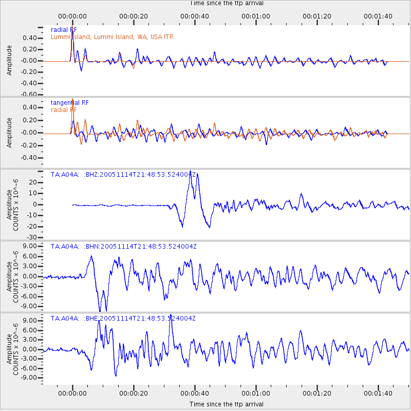
Signal To Noise
| Channel | StoN | STA | LTA |
| TA:A04A: :BHN:20051114T21:48:53.524004Z | 2.1339378 | 7.13207E-7 | 3.3422108E-7 |
| TA:A04A: :BHE:20051114T21:48:53.524004Z | 2.6710687 | 9.107655E-7 | 3.409742E-7 |
| TA:A04A: :BHZ:20051114T21:48:53.524004Z | 8.400792 | 2.8035406E-6 | 3.337234E-7 |
| Arrivals |
| Ps | 4.3 SECOND |
| PpPs | 15 SECOND |
| PsPs/PpSs | 20 SECOND |


