You are here: Home > Network List > TA - USArray Transportable Network (new EarthScope stations) Stations List
> Station E22K Anaktuvuk Pass, AK, USA > Earthquake Result Viewer
E22K Anaktuvuk Pass, AK, USA - Earthquake Result Viewer
| Earthquake location: |
Seram, Indonesia |
| Earthquake latitude/longitude: |
-3.4/128.4 |
| Earthquake time(UTC): |
2019/09/25 (268) 23:46:46 GMT |
| Earthquake Depth: |
30 km |
| Earthquake Magnitude: |
6.5 Mww |
| Earthquake Catalog/Contributor: |
NEIC PDE/us |
|
| Network: |
TA USArray Transportable Network (new EarthScope stations) |
| Station: |
E22K Anaktuvuk Pass, AK, USA |
| Lat/Lon: |
68.13 N/151.81 W |
| Elevation: |
772 m |
|
| Distance: |
89.4 deg |
| Az: |
21.636 deg |
| Baz: |
259.279 deg |
| Ray Param: |
0.041870065 |
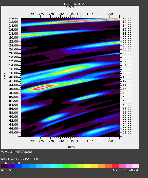
| Estimated Moho Depth: |
10.75 km |
| Estimated Crust Vp/Vs: |
2.03 |
| Assumed Crust Vp: |
6.221 km/s |
| Estimated Crust Vs: |
3.061 km/s |
| Estimated Crust Poisson's Ratio: |
0.34 |
|
| Radial Match: |
87.73682 % |
| Radial Bump: |
400 |
| Transverse Match: |
73.04615 % |
| Transverse Bump: |
400 |
| SOD ConfigId: |
19053131 |
| Insert Time: |
2019-10-09 23:51:26.526 +0000 |
| GWidth: |
2.5 |
| Max Bumps: |
400 |
| Tol: |
0.001 |
|

Signal To Noise
| Channel | StoN | STA | LTA |
| TA:E22K: :BHZ:20190925T23:59:08.775029Z | 4.3202724 | 3.422613E-7 | 7.9222154E-8 |
| TA:E22K: :BHN:20190925T23:59:08.775029Z | 1.0788352 | 8.7729866E-8 | 8.1319065E-8 |
| TA:E22K: :BHE:20190925T23:59:08.775029Z | 0.9336976 | 7.343822E-8 | 7.8653116E-8 |
| Arrivals |
| Ps | 1.8 SECOND |
| PpPs | 5.2 SECOND |
| PsPs/PpSs | 7.0 SECOND |


