You are here: Home > Network List > TA - USArray Transportable Network (new EarthScope stations) Stations List
> Station G18K Tagagawik, AK, USA > Earthquake Result Viewer
G18K Tagagawik, AK, USA - Earthquake Result Viewer
| Earthquake location: |
Seram, Indonesia |
| Earthquake latitude/longitude: |
-3.4/128.4 |
| Earthquake time(UTC): |
2019/09/25 (268) 23:46:46 GMT |
| Earthquake Depth: |
30 km |
| Earthquake Magnitude: |
6.5 Mww |
| Earthquake Catalog/Contributor: |
NEIC PDE/us |
|
| Network: |
TA USArray Transportable Network (new EarthScope stations) |
| Station: |
G18K Tagagawik, AK, USA |
| Lat/Lon: |
65.89 N/158.65 W |
| Elevation: |
484 m |
|
| Distance: |
86.2 deg |
| Az: |
23.175 deg |
| Baz: |
253.045 deg |
| Ray Param: |
0.04417217 |
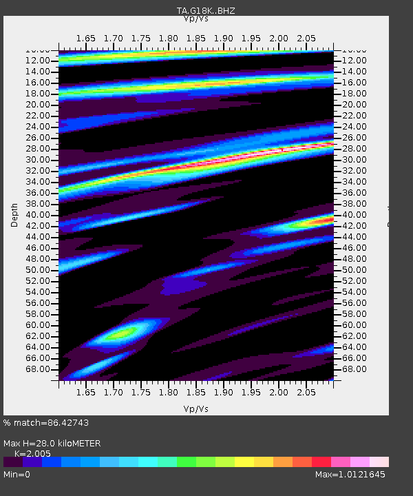
| Estimated Moho Depth: |
28.0 km |
| Estimated Crust Vp/Vs: |
2.01 |
| Assumed Crust Vp: |
6.1 km/s |
| Estimated Crust Vs: |
3.042 km/s |
| Estimated Crust Poisson's Ratio: |
0.33 |
|
| Radial Match: |
86.42743 % |
| Radial Bump: |
391 |
| Transverse Match: |
72.34448 % |
| Transverse Bump: |
400 |
| SOD ConfigId: |
19053131 |
| Insert Time: |
2019-10-09 23:51:35.179 +0000 |
| GWidth: |
2.5 |
| Max Bumps: |
400 |
| Tol: |
0.001 |
|

Signal To Noise
| Channel | StoN | STA | LTA |
| TA:G18K: :BHZ:20190925T23:58:53.750004Z | 2.489326 | 3.2052804E-7 | 1.2876097E-7 |
| TA:G18K: :BHN:20190925T23:58:53.750004Z | 0.7202531 | 1.1619946E-7 | 1.6133143E-7 |
| TA:G18K: :BHE:20190925T23:58:53.750004Z | 1.4991016 | 1.7342376E-7 | 1.15685125E-7 |
| Arrivals |
| Ps | 4.7 SECOND |
| PpPs | 14 SECOND |
| PsPs/PpSs | 18 SECOND |


