You are here: Home > Network List > TA - USArray Transportable Network (new EarthScope stations) Stations List
> Station A04A Lummi Island, Lummi Island, WA, USA > Earthquake Result Viewer
A04A Lummi Island, Lummi Island, WA, USA - Earthquake Result Viewer
| Earthquake location: |
Nicaragua |
| Earthquake latitude/longitude: |
11.2/-85.5 |
| Earthquake time(UTC): |
2005/08/03 (215) 11:03:15 GMT |
| Earthquake Depth: |
14 km |
| Earthquake Magnitude: |
6.0 MB, 6.5 MS, 6.3 MW, 6.3 MW |
| Earthquake Catalog/Contributor: |
WHDF/NEIC |
|
| Network: |
TA USArray Transportable Network (new EarthScope stations) |
| Station: |
A04A Lummi Island, Lummi Island, WA, USA |
| Lat/Lon: |
48.72 N/122.71 W |
| Elevation: |
23 m |
|
| Distance: |
48.5 deg |
| Az: |
327.699 deg |
| Baz: |
127.663 deg |
| Ray Param: |
0.06932596 |
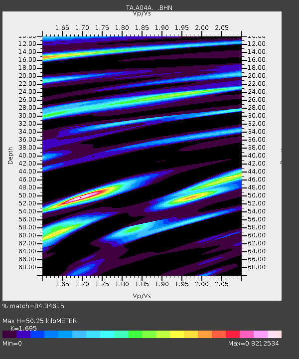
| Estimated Moho Depth: |
50.25 km |
| Estimated Crust Vp/Vs: |
1.70 |
| Assumed Crust Vp: |
6.566 km/s |
| Estimated Crust Vs: |
3.874 km/s |
| Estimated Crust Poisson's Ratio: |
0.23 |
|
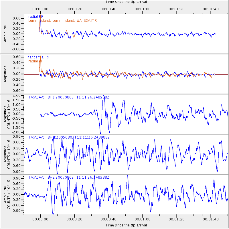
| Radial Match: |
84.34615 % |
| Radial Bump: |
400 |
| Transverse Match: |
65.99507 % |
| Transverse Bump: |
400 |
| SOD ConfigId: |
2475 |
| Insert Time: |
2010-03-07 04:36:28.482 +0000 |
| GWidth: |
2.5 |
| Max Bumps: |
400 |
| Tol: |
0.001 |
|
Signal To Noise
| Channel | StoN | STA | LTA |
| TA:A04A: :BHN:20050803T11:11:26.248988Z | 0.93808985 | 1.4033176E-7 | 1.4959309E-7 |
| TA:A04A: :BHE:20050803T11:11:26.248988Z | 1.8897579 | 2.32417E-7 | 1.2298771E-7 |
| TA:A04A: :BHZ:20050803T11:11:26.248988Z | 3.4791393 | 4.0352472E-7 | 1.15984065E-7 |
| Arrivals |
| Ps | 5.7 SECOND |
| PpPs | 19 SECOND |
| PsPs/PpSs | 25 SECOND |


