You are here: Home > Network List > TA - USArray Transportable Network (new EarthScope stations) Stations List
> Station A04A Lummi Island, Lummi Island, WA, USA > Earthquake Result Viewer
A04A Lummi Island, Lummi Island, WA, USA - Earthquake Result Viewer
| Earthquake location: |
Near Coast Of Nicaragua |
| Earthquake latitude/longitude: |
11.2/-86.2 |
| Earthquake time(UTC): |
2005/07/02 (183) 02:16:43 GMT |
| Earthquake Depth: |
27 km |
| Earthquake Magnitude: |
5.6 MB, 6.4 MS, 6.6 MW, 6.6 MW |
| Earthquake Catalog/Contributor: |
WHDF/NEIC |
|
| Network: |
TA USArray Transportable Network (new EarthScope stations) |
| Station: |
A04A Lummi Island, Lummi Island, WA, USA |
| Lat/Lon: |
48.72 N/122.71 W |
| Elevation: |
23 m |
|
| Distance: |
48.1 deg |
| Az: |
328.044 deg |
| Baz: |
128.366 deg |
| Ray Param: |
0.0694987 |
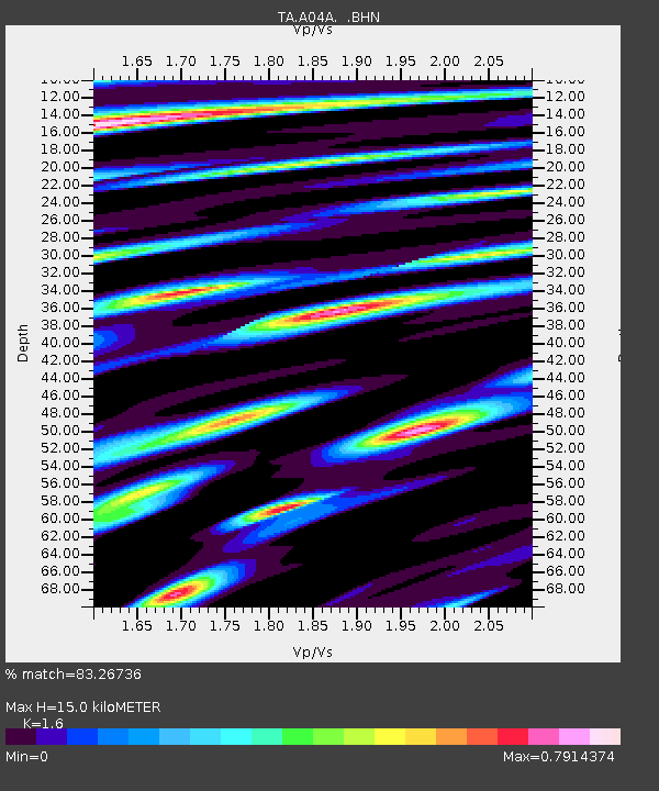
| Estimated Moho Depth: |
15.0 km |
| Estimated Crust Vp/Vs: |
1.60 |
| Assumed Crust Vp: |
6.566 km/s |
| Estimated Crust Vs: |
4.104 km/s |
| Estimated Crust Poisson's Ratio: |
0.18 |
|
| Radial Match: |
83.26736 % |
| Radial Bump: |
400 |
| Transverse Match: |
64.580414 % |
| Transverse Bump: |
400 |
| SOD ConfigId: |
2475 |
| Insert Time: |
2010-03-07 04:36:29.926 +0000 |
| GWidth: |
2.5 |
| Max Bumps: |
400 |
| Tol: |
0.001 |
|

Signal To Noise
| Channel | StoN | STA | LTA |
| TA:A04A: :BHN:20050702T02:24:50.650012Z | 4.6502967 | 1.2217777E-6 | 2.627311E-7 |
| TA:A04A: :BHE:20050702T02:24:50.650012Z | 3.6196141 | 1.2409956E-6 | 3.42853E-7 |
| TA:A04A: :BHZ:20050702T02:24:50.650012Z | 23.659506 | 2.8750271E-6 | 1.2151679E-7 |
| Arrivals |
| Ps | 1.5 SECOND |
| PpPs | 5.5 SECOND |
| PsPs/PpSs | 7.0 SECOND |


