You are here: Home > Network List > TA - USArray Transportable Network (new EarthScope stations) Stations List
> Station J14K Nanvaranak Lake, AK, USA > Earthquake Result Viewer
J14K Nanvaranak Lake, AK, USA - Earthquake Result Viewer
| Earthquake location: |
Seram, Indonesia |
| Earthquake latitude/longitude: |
-3.4/128.4 |
| Earthquake time(UTC): |
2019/09/25 (268) 23:46:46 GMT |
| Earthquake Depth: |
30 km |
| Earthquake Magnitude: |
6.5 Mww |
| Earthquake Catalog/Contributor: |
NEIC PDE/us |
|
| Network: |
TA USArray Transportable Network (new EarthScope stations) |
| Station: |
J14K Nanvaranak Lake, AK, USA |
| Lat/Lon: |
62.75 N/163.55 W |
| Elevation: |
25 m |
|
| Distance: |
83.2 deg |
| Az: |
25.471 deg |
| Baz: |
248.845 deg |
| Ray Param: |
0.04634171 |
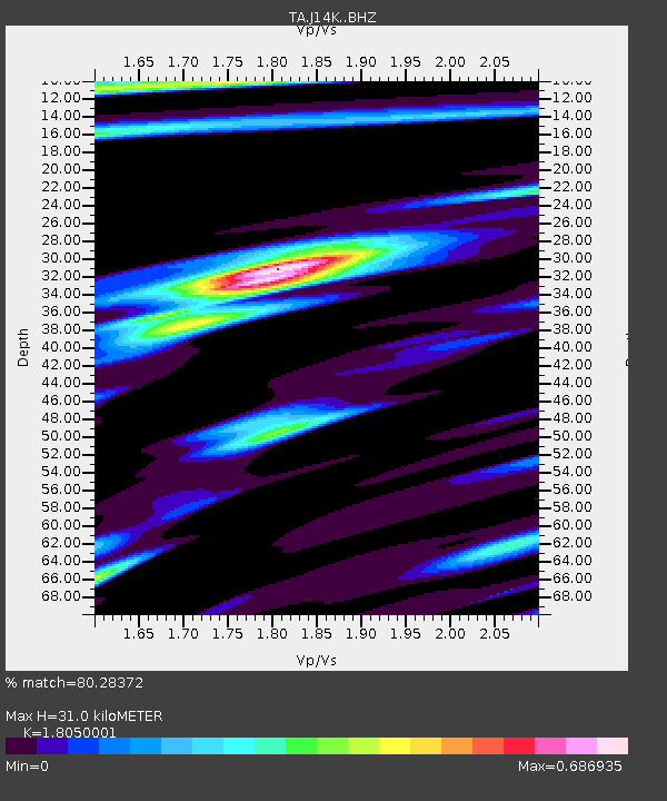
| Estimated Moho Depth: |
31.0 km |
| Estimated Crust Vp/Vs: |
1.81 |
| Assumed Crust Vp: |
6.155 km/s |
| Estimated Crust Vs: |
3.41 km/s |
| Estimated Crust Poisson's Ratio: |
0.28 |
|
| Radial Match: |
80.28372 % |
| Radial Bump: |
356 |
| Transverse Match: |
65.51543 % |
| Transverse Bump: |
400 |
| SOD ConfigId: |
19053131 |
| Insert Time: |
2019-10-09 23:51:47.186 +0000 |
| GWidth: |
2.5 |
| Max Bumps: |
400 |
| Tol: |
0.001 |
|

Signal To Noise
| Channel | StoN | STA | LTA |
| TA:J14K: :BHZ:20190925T23:58:38.450017Z | 2.2501085 | 9.252623E-7 | 4.1120788E-7 |
| TA:J14K: :BHN:20190925T23:58:38.450017Z | 1.7794354 | 4.9666687E-7 | 2.7911486E-7 |
| TA:J14K: :BHE:20190925T23:58:38.450017Z | 0.73881006 | 1.8153169E-7 | 2.457082E-7 |
| Arrivals |
| Ps | 4.1 SECOND |
| PpPs | 14 SECOND |
| PsPs/PpSs | 18 SECOND |


