You are here: Home > Network List > TA - USArray Transportable Network (new EarthScope stations) Stations List
> Station A04A Lummi Island, Lummi Island, WA, USA > Earthquake Result Viewer
A04A Lummi Island, Lummi Island, WA, USA - Earthquake Result Viewer

| Earthquake location: |
Southern Peru |
| Earthquake latitude/longitude: |
-15.3/-73.0 |
| Earthquake time(UTC): |
2005/07/26 (207) 14:11:36 GMT |
| Earthquake Depth: |
110 km |
| Earthquake Magnitude: |
5.8 MB, 6.0 MW, 5.9 MW |
| Earthquake Catalog/Contributor: |
WHDF/NEIC |
|
| Network: |
TA USArray Transportable Network (new EarthScope stations) |
| Station: |
A04A Lummi Island, Lummi Island, WA, USA |
| Lat/Lon: |
48.72 N/122.71 W |
| Elevation: |
23 m |
|
| Distance: |
77.5 deg |
| Az: |
328.828 deg |
| Baz: |
131.055 deg |
| Ray Param: |
0.04999676 |
| Estimated Moho Depth: |
63.75 km |
| Estimated Crust Vp/Vs: |
2.10 |
| Assumed Crust Vp: |
6.566 km/s |
| Estimated Crust Vs: |
3.13 km/s |
| Estimated Crust Poisson's Ratio: |
0.35 |
|
| Radial Match: |
82.929955 % |
| Radial Bump: |
400 |
| Transverse Match: |
84.10572 % |
| Transverse Bump: |
400 |
| SOD ConfigId: |
2475 |
| Insert Time: |
2010-03-07 04:36:33.487 +0000 |
| GWidth: |
2.5 |
| Max Bumps: |
400 |
| Tol: |
0.001 |
|
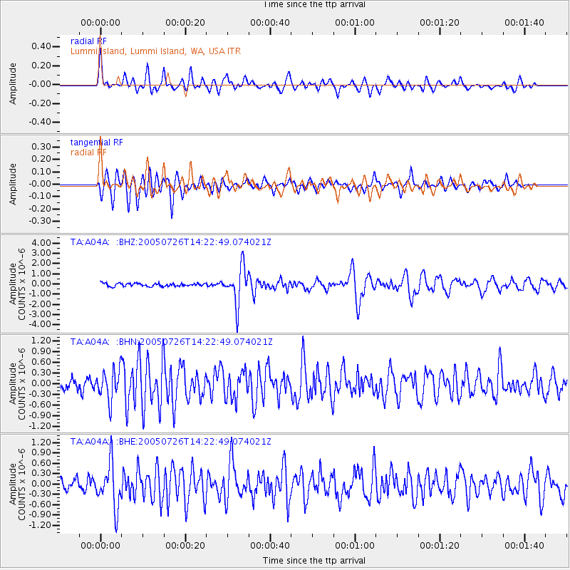
Signal To Noise
| Channel | StoN | STA | LTA |
| TA:A04A: :BHN:20050726T14:22:49.074021Z | 3.0116997 | 4.336247E-7 | 1.4398006E-7 |
| TA:A04A: :BHE:20050726T14:22:49.074021Z | 4.581109 | 6.6391044E-7 | 1.4492352E-7 |
| TA:A04A: :BHZ:20050726T14:22:49.074021Z | 12.69632 | 1.8243608E-6 | 1.4369209E-7 |
| Arrivals |
| Ps | 11 SECOND |
| PpPs | 29 SECOND |
| PsPs/PpSs | 40 SECOND |


