You are here: Home > Network List > TA - USArray Transportable Network (new EarthScope stations) Stations List
> Station M20K Styx River, AK, USA > Earthquake Result Viewer
M20K Styx River, AK, USA - Earthquake Result Viewer
| Earthquake location: |
Seram, Indonesia |
| Earthquake latitude/longitude: |
-3.4/128.4 |
| Earthquake time(UTC): |
2019/09/25 (268) 23:46:46 GMT |
| Earthquake Depth: |
30 km |
| Earthquake Magnitude: |
6.5 Mww |
| Earthquake Catalog/Contributor: |
NEIC PDE/us |
|
| Network: |
TA USArray Transportable Network (new EarthScope stations) |
| Station: |
M20K Styx River, AK, USA |
| Lat/Lon: |
61.88 N/153.13 W |
| Elevation: |
1107 m |
|
| Distance: |
87.6 deg |
| Az: |
27.687 deg |
| Baz: |
258.245 deg |
| Ray Param: |
0.043181803 |
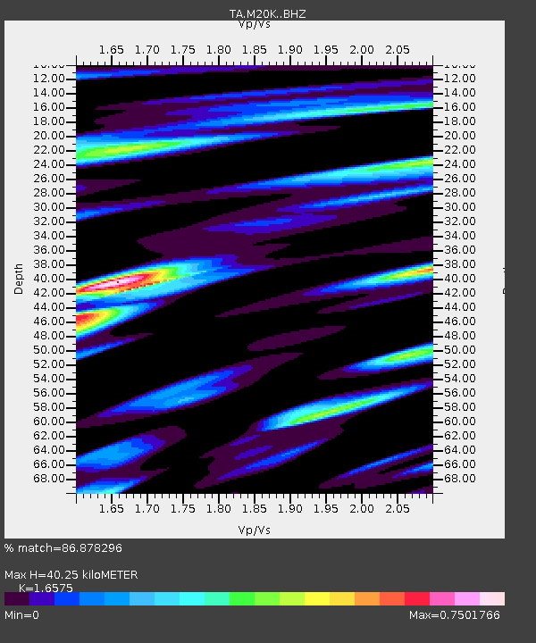
| Estimated Moho Depth: |
40.25 km |
| Estimated Crust Vp/Vs: |
1.66 |
| Assumed Crust Vp: |
6.566 km/s |
| Estimated Crust Vs: |
3.961 km/s |
| Estimated Crust Poisson's Ratio: |
0.21 |
|
| Radial Match: |
86.878296 % |
| Radial Bump: |
400 |
| Transverse Match: |
75.36407 % |
| Transverse Bump: |
400 |
| SOD ConfigId: |
19053131 |
| Insert Time: |
2019-10-09 23:52:00.548 +0000 |
| GWidth: |
2.5 |
| Max Bumps: |
400 |
| Tol: |
0.001 |
|

Signal To Noise
| Channel | StoN | STA | LTA |
| TA:M20K: :BHZ:20190925T23:59:00.400029Z | 4.080726 | 5.335517E-7 | 1.307492E-7 |
| TA:M20K: :BHN:20190925T23:59:00.400029Z | 1.2212652 | 1.5154615E-7 | 1.2408947E-7 |
| TA:M20K: :BHE:20190925T23:59:00.400029Z | 2.194449 | 2.1671757E-7 | 9.875717E-8 |
| Arrivals |
| Ps | 4.1 SECOND |
| PpPs | 16 SECOND |
| PsPs/PpSs | 20 SECOND |


