You are here: Home > Network List > PF - Volcanologic Network of Piton de Fournaise-OVPF Stations List
> Station GPN Grandes Pentes Nord > Earthquake Result Viewer
GPN Grandes Pentes Nord - Earthquake Result Viewer
| Earthquake location: |
Solomon Islands |
| Earthquake latitude/longitude: |
-6.2/155.1 |
| Earthquake time(UTC): |
2017/01/22 (022) 04:30:23 GMT |
| Earthquake Depth: |
136 km |
| Earthquake Magnitude: |
7.9 mww |
| Earthquake Catalog/Contributor: |
NEIC PDE/us |
|
| Network: |
PF Volcanologic Network of Piton de Fournaise-OVPF |
| Station: |
GPN Grandes Pentes Nord |
| Lat/Lon: |
21.24 S/55.75 E |
| Elevation: |
1413 m |
|
| Distance: |
96.4 deg |
| Az: |
247.865 deg |
| Baz: |
99.184 deg |
| Ray Param: |
0.04039856 |
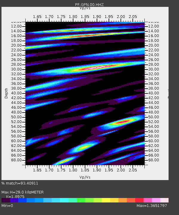
| Estimated Moho Depth: |
29.0 km |
| Estimated Crust Vp/Vs: |
1.90 |
| Assumed Crust Vp: |
4.73 km/s |
| Estimated Crust Vs: |
2.493 km/s |
| Estimated Crust Poisson's Ratio: |
0.31 |
|
| Radial Match: |
93.40911 % |
| Radial Bump: |
400 |
| Transverse Match: |
79.69109 % |
| Transverse Bump: |
400 |
| SOD ConfigId: |
1943534 |
| Insert Time: |
2017-02-05 04:35:02.522 +0000 |
| GWidth: |
2.5 |
| Max Bumps: |
400 |
| Tol: |
0.001 |
|
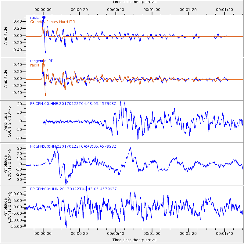
Signal To Noise
| Channel | StoN | STA | LTA |
| PF:GPN:00:HHZ:20170122T04:43:05.457993Z | 9.974281 | 5.759435E-6 | 5.7742864E-7 |
| PF:GPN:00:HHN:20170122T04:43:05.457993Z | 1.4154621 | 1.349789E-6 | 9.536031E-7 |
| PF:GPN:00:HHE:20170122T04:43:05.457993Z | 3.0741155 | 2.463838E-6 | 8.014786E-7 |
| Arrivals |
| Ps | 5.6 SECOND |
| PpPs | 18 SECOND |
| PsPs/PpSs | 23 SECOND |


