You are here: Home > Network List > PF - Volcanologic Network of Piton de Fournaise-OVPF Stations List
> Station HDL Station Sismologique de Hubert Delisle > Earthquake Result Viewer
HDL Station Sismologique de Hubert Delisle - Earthquake Result Viewer
| Earthquake location: |
Solomon Islands |
| Earthquake latitude/longitude: |
-6.2/155.1 |
| Earthquake time(UTC): |
2017/01/22 (022) 04:30:23 GMT |
| Earthquake Depth: |
136 km |
| Earthquake Magnitude: |
7.9 mww |
| Earthquake Catalog/Contributor: |
NEIC PDE/us |
|
| Network: |
PF Volcanologic Network of Piton de Fournaise-OVPF |
| Station: |
HDL Station Sismologique de Hubert Delisle |
| Lat/Lon: |
21.25 S/55.79 E |
| Elevation: |
242 m |
|
| Distance: |
96.4 deg |
| Az: |
247.86 deg |
| Baz: |
99.171 deg |
| Ray Param: |
0.04040964 |
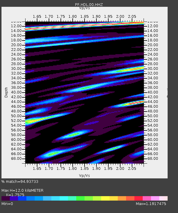
| Estimated Moho Depth: |
12.0 km |
| Estimated Crust Vp/Vs: |
1.76 |
| Assumed Crust Vp: |
4.73 km/s |
| Estimated Crust Vs: |
2.691 km/s |
| Estimated Crust Poisson's Ratio: |
0.26 |
|
| Radial Match: |
94.93733 % |
| Radial Bump: |
400 |
| Transverse Match: |
66.05412 % |
| Transverse Bump: |
400 |
| SOD ConfigId: |
1943534 |
| Insert Time: |
2017-02-05 04:35:05.469 +0000 |
| GWidth: |
2.5 |
| Max Bumps: |
400 |
| Tol: |
0.001 |
|
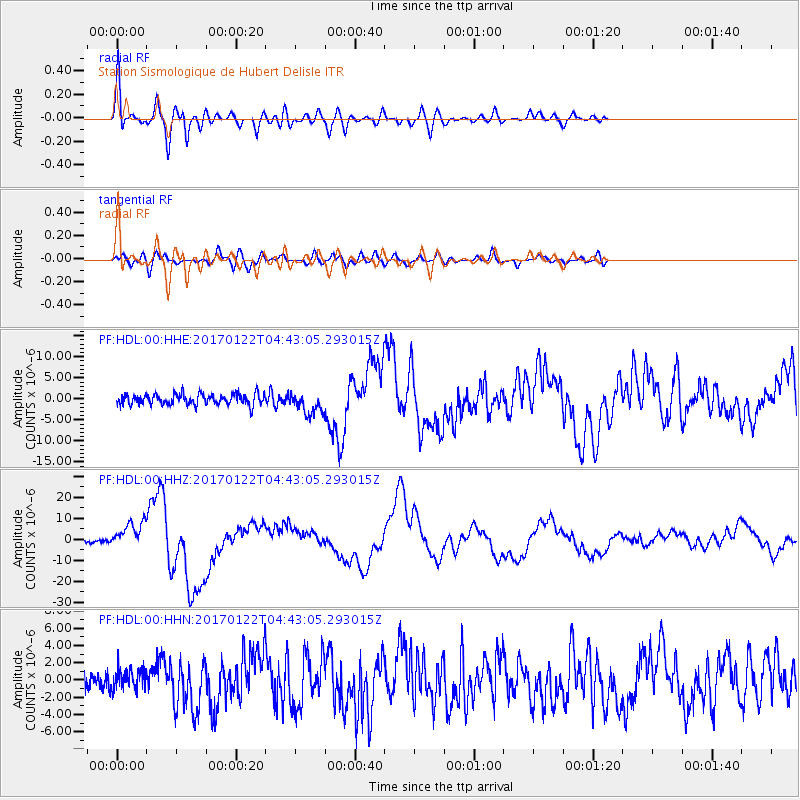
Signal To Noise
| Channel | StoN | STA | LTA |
| PF:HDL:00:HHZ:20170122T04:43:05.293015Z | 9.706344 | 6.3043913E-6 | 6.4951246E-7 |
| PF:HDL:00:HHN:20170122T04:43:05.293015Z | 1.1108967 | 1.1561588E-6 | 1.0407437E-6 |
| PF:HDL:00:HHE:20170122T04:43:05.293015Z | 2.028465 | 2.5672334E-6 | 1.2656039E-6 |
| Arrivals |
| Ps | 1.9 SECOND |
| PpPs | 6.9 SECOND |
| PsPs/PpSs | 8.9 SECOND |


