You are here: Home > Network List > TA - USArray Transportable Network (new EarthScope stations) Stations List
> Station A04A Lummi Island, Lummi Island, WA, USA > Earthquake Result Viewer
A04A Lummi Island, Lummi Island, WA, USA - Earthquake Result Viewer
| Earthquake location: |
Guerrero, Mexico |
| Earthquake latitude/longitude: |
18.6/-101.1 |
| Earthquake time(UTC): |
2006/08/11 (223) 14:30:40 GMT |
| Earthquake Depth: |
60 km |
| Earthquake Magnitude: |
6.0 MB, 6.1 MW, 6.0 MW |
| Earthquake Catalog/Contributor: |
WHDF/NEIC |
|
| Network: |
TA USArray Transportable Network (new EarthScope stations) |
| Station: |
A04A Lummi Island, Lummi Island, WA, USA |
| Lat/Lon: |
48.72 N/122.71 W |
| Elevation: |
23 m |
|
| Distance: |
34.8 deg |
| Az: |
334.668 deg |
| Baz: |
142.202 deg |
| Ray Param: |
0.07738715 |
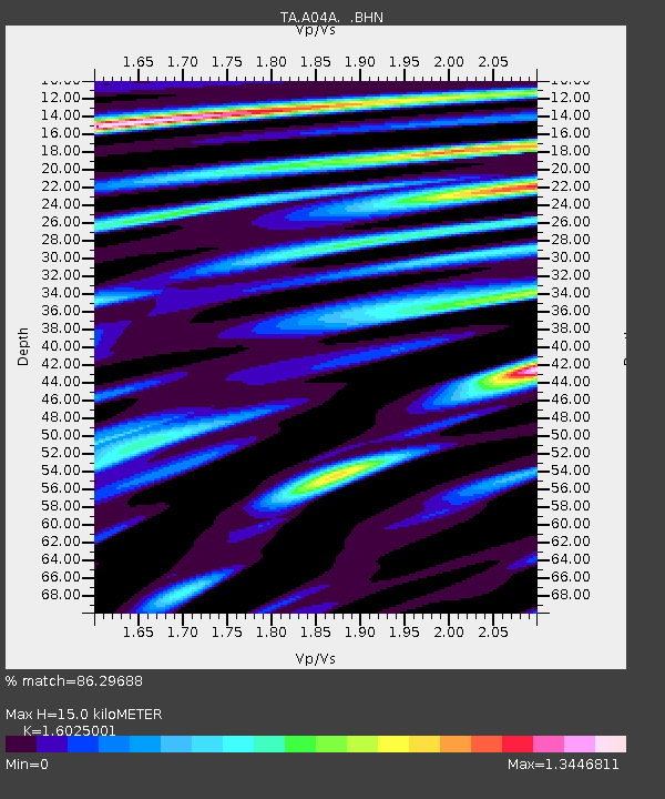
| Estimated Moho Depth: |
15.0 km |
| Estimated Crust Vp/Vs: |
1.60 |
| Assumed Crust Vp: |
6.566 km/s |
| Estimated Crust Vs: |
4.097 km/s |
| Estimated Crust Poisson's Ratio: |
0.18 |
|
| Radial Match: |
86.29688 % |
| Radial Bump: |
400 |
| Transverse Match: |
68.51567 % |
| Transverse Bump: |
400 |
| SOD ConfigId: |
2665 |
| Insert Time: |
2010-03-07 04:36:54.998 +0000 |
| GWidth: |
2.5 |
| Max Bumps: |
400 |
| Tol: |
0.001 |
|
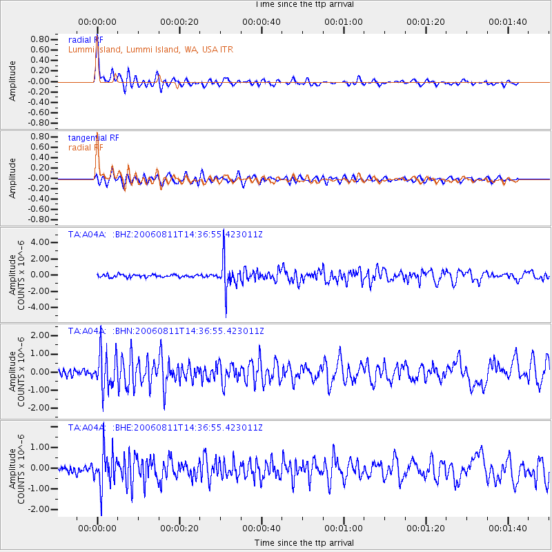
Signal To Noise
| Channel | StoN | STA | LTA |
| TA:A04A: :BHN:20060811T14:36:55.423011Z | 6.632549 | 9.872782E-7 | 1.4885352E-7 |
| TA:A04A: :BHE:20060811T14:36:55.423011Z | 3.9759822 | 8.4498333E-7 | 2.1252191E-7 |
| TA:A04A: :BHZ:20060811T14:36:55.423011Z | 11.106034 | 1.7573925E-6 | 1.5823763E-7 |
| Arrivals |
| Ps | 1.5 SECOND |
| PpPs | 5.4 SECOND |
| PsPs/PpSs | 6.9 SECOND |


