You are here: Home > Network List > TA - USArray Transportable Network (new EarthScope stations) Stations List
> Station A04A Lummi Island, Lummi Island, WA, USA > Earthquake Result Viewer
A04A Lummi Island, Lummi Island, WA, USA - Earthquake Result Viewer
| Earthquake location: |
Tonga Islands |
| Earthquake latitude/longitude: |
-15.2/-173.6 |
| Earthquake time(UTC): |
2006/07/07 (188) 07:26:12 GMT |
| Earthquake Depth: |
35 km |
| Earthquake Magnitude: |
5.7 MB, 5.9 MS, 6.0 MW, 6.0 MW |
| Earthquake Catalog/Contributor: |
WHDF/NEIC |
|
| Network: |
TA USArray Transportable Network (new EarthScope stations) |
| Station: |
A04A Lummi Island, Lummi Island, WA, USA |
| Lat/Lon: |
48.72 N/122.71 W |
| Elevation: |
23 m |
|
| Distance: |
78.0 deg |
| Az: |
31.693 deg |
| Baz: |
229.975 deg |
| Ray Param: |
0.049866676 |
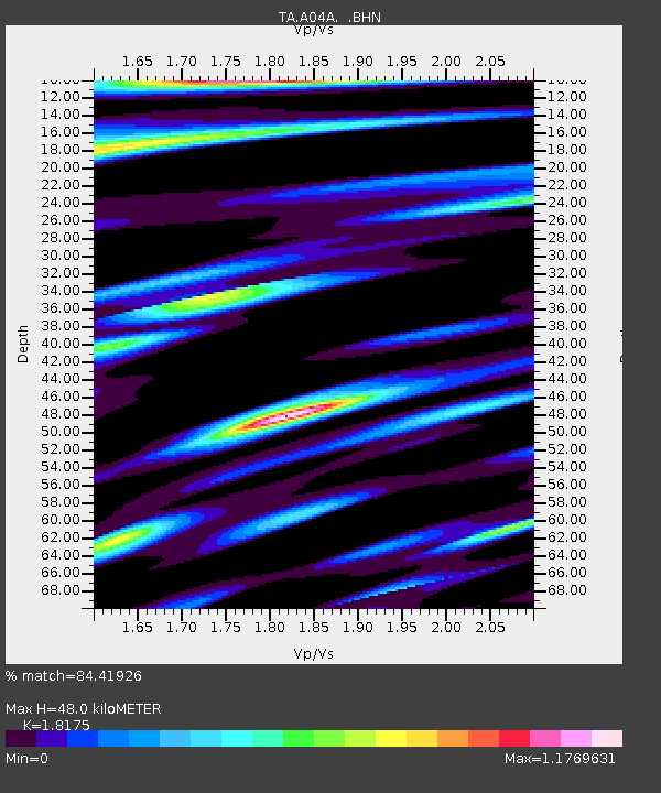
| Estimated Moho Depth: |
48.0 km |
| Estimated Crust Vp/Vs: |
1.82 |
| Assumed Crust Vp: |
6.566 km/s |
| Estimated Crust Vs: |
3.613 km/s |
| Estimated Crust Poisson's Ratio: |
0.28 |
|
| Radial Match: |
84.41926 % |
| Radial Bump: |
400 |
| Transverse Match: |
82.97013 % |
| Transverse Bump: |
400 |
| SOD ConfigId: |
2665 |
| Insert Time: |
2010-03-07 04:36:58.242 +0000 |
| GWidth: |
2.5 |
| Max Bumps: |
400 |
| Tol: |
0.001 |
|

Signal To Noise
| Channel | StoN | STA | LTA |
| TA:A04A: :BHN:20060707T07:37:36.498018Z | 1.6553949 | 1.7023402E-7 | 1.0283589E-7 |
| TA:A04A: :BHE:20060707T07:37:36.498018Z | 2.2904084 | 2.1014434E-7 | 9.174972E-8 |
| TA:A04A: :BHZ:20060707T07:37:36.498018Z | 6.6323276 | 5.7569565E-7 | 8.680145E-8 |
| Arrivals |
| Ps | 6.2 SECOND |
| PpPs | 20 SECOND |
| PsPs/PpSs | 26 SECOND |


