You are here: Home > Network List > TS - TERRAscope (Southern California Seismic Network) Stations List
> Station MLAC Mammoth Lakes, California, USA > Earthquake Result Viewer
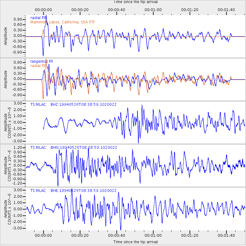
MLAC Mammoth Lakes, California, USA - Earthquake Result Viewer
*The percent match for this event was below the threshold and hence no stack was calculated.
| Earthquake location: |
Strait Of Gibraltar |
| Earthquake latitude/longitude: |
35.4/-4.1 |
| Earthquake time(UTC): |
1994/05/26 (146) 08:26:52 GMT |
| Earthquake Depth: |
10 km |
| Earthquake Magnitude: |
5.7 MB, 5.8 MS, 5.9 UNKNOWN |
| Earthquake Catalog/Contributor: |
WHDF/NEIC |
|
| Network: |
TS TERRAscope (Southern California Seismic Network) |
| Station: |
MLAC Mammoth Lakes, California, USA |
| Lat/Lon: |
37.63 N/118.83 W |
| Elevation: |
2170 m |
|
| Distance: |
85.5 deg |
| Az: |
313.658 deg |
| Baz: |
48.133 deg |
| Ray Param: |
$rayparam |
*The percent match for this event was below the threshold and hence was not used in the summary stack. |
|
| Radial Match: |
65.69156 % |
| Radial Bump: |
400 |
| Transverse Match: |
68.92604 % |
| Transverse Bump: |
400 |
| SOD ConfigId: |
4480 |
| Insert Time: |
2010-02-26 14:29:55.449 +0000 |
| GWidth: |
2.5 |
| Max Bumps: |
400 |
| Tol: |
0.001 |
|
Signal To Noise
| Channel | StoN | STA | LTA |
| TS:MLAC: :BHN:19940526T08:38:59.102002Z | 0.64294255 | 1.1314358E-7 | 1.7597775E-7 |
| TS:MLAC: :BHE:19940526T08:38:59.102002Z | 0.82967377 | 4.1191277E-7 | 4.964756E-7 |
| TS:MLAC: :BHZ:19940526T08:38:59.102002Z | 0.72880596 | 4.1128243E-7 | 5.643236E-7 |
| Arrivals |
| Ps | |
| PpPs | |
| PsPs/PpSs | |


