You are here: Home > Network List > TA - USArray Transportable Network (new EarthScope stations) Stations List
> Station A04A Lummi Island, Lummi Island, WA, USA > Earthquake Result Viewer
A04A Lummi Island, Lummi Island, WA, USA - Earthquake Result Viewer
| Earthquake location: |
Rat Islands, Aleutian Islands |
| Earthquake latitude/longitude: |
51.8/177.1 |
| Earthquake time(UTC): |
2006/06/14 (165) 04:18:42 GMT |
| Earthquake Depth: |
14 km |
| Earthquake Magnitude: |
5.9 MB, 6.4 MS, 6.4 MW, 6.4 MW |
| Earthquake Catalog/Contributor: |
WHDF/NEIC |
|
| Network: |
TA USArray Transportable Network (new EarthScope stations) |
| Station: |
A04A Lummi Island, Lummi Island, WA, USA |
| Lat/Lon: |
48.72 N/122.71 W |
| Elevation: |
23 m |
|
| Distance: |
37.7 deg |
| Az: |
70.098 deg |
| Baz: |
298.04 deg |
| Ray Param: |
0.07599138 |
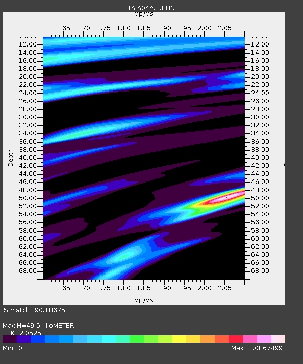
| Estimated Moho Depth: |
49.5 km |
| Estimated Crust Vp/Vs: |
2.05 |
| Assumed Crust Vp: |
6.566 km/s |
| Estimated Crust Vs: |
3.199 km/s |
| Estimated Crust Poisson's Ratio: |
0.34 |
|
| Radial Match: |
90.18675 % |
| Radial Bump: |
376 |
| Transverse Match: |
87.62021 % |
| Transverse Bump: |
400 |
| SOD ConfigId: |
5745 |
| Insert Time: |
2010-03-07 04:37:01.094 +0000 |
| GWidth: |
2.5 |
| Max Bumps: |
400 |
| Tol: |
0.001 |
|
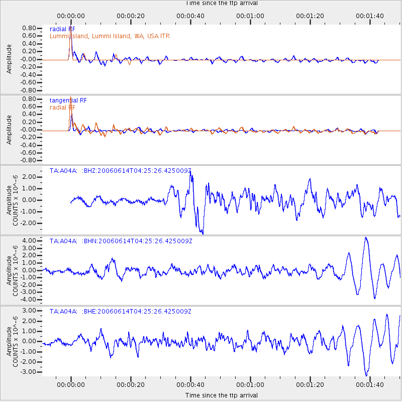
Signal To Noise
| Channel | StoN | STA | LTA |
| TA:A04A: :BHN:20060614T04:25:26.425009Z | 1.421726 | 2.891546E-7 | 2.033828E-7 |
| TA:A04A: :BHE:20060614T04:25:26.425009Z | 2.615838 | 3.8088587E-7 | 1.4560759E-7 |
| TA:A04A: :BHZ:20060614T04:25:26.425009Z | 3.1234586 | 6.550545E-7 | 2.0972088E-7 |
| Arrivals |
| Ps | 8.5 SECOND |
| PpPs | 22 SECOND |
| PsPs/PpSs | 30 SECOND |


