You are here: Home > Network List > TA - USArray Transportable Network (new EarthScope stations) Stations List
> Station A04A Lummi Island, Lummi Island, WA, USA > Earthquake Result Viewer
A04A Lummi Island, Lummi Island, WA, USA - Earthquake Result Viewer
| Earthquake location: |
Eastern Siberia, Russia |
| Earthquake latitude/longitude: |
60.5/167.5 |
| Earthquake time(UTC): |
2006/04/29 (119) 16:58:06 GMT |
| Earthquake Depth: |
11 km |
| Earthquake Magnitude: |
6.4 MB, 6.6 MS, 6.6 MW, 6.4 MW |
| Earthquake Catalog/Contributor: |
WHDF/NEIC |
|
| Network: |
TA USArray Transportable Network (new EarthScope stations) |
| Station: |
A04A Lummi Island, Lummi Island, WA, USA |
| Lat/Lon: |
48.72 N/122.71 W |
| Elevation: |
23 m |
|
| Distance: |
40.2 deg |
| Az: |
74.524 deg |
| Baz: |
313.907 deg |
| Ray Param: |
0.07455441 |
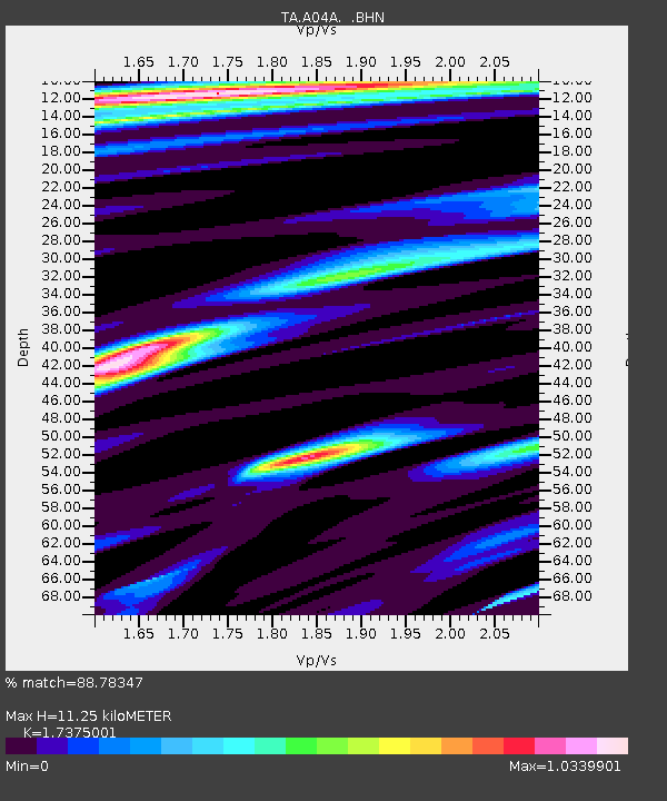
| Estimated Moho Depth: |
11.25 km |
| Estimated Crust Vp/Vs: |
1.74 |
| Assumed Crust Vp: |
6.566 km/s |
| Estimated Crust Vs: |
3.779 km/s |
| Estimated Crust Poisson's Ratio: |
0.25 |
|
| Radial Match: |
88.78347 % |
| Radial Bump: |
358 |
| Transverse Match: |
77.91629 % |
| Transverse Bump: |
400 |
| SOD ConfigId: |
5423 |
| Insert Time: |
2010-03-07 04:37:09.612 +0000 |
| GWidth: |
2.5 |
| Max Bumps: |
400 |
| Tol: |
0.001 |
|
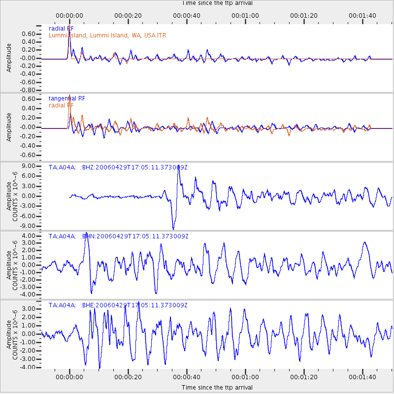
Signal To Noise
| Channel | StoN | STA | LTA |
| TA:A04A: :BHN:20060429T17:05:11.373009Z | 1.2760526 | 5.7682513E-7 | 4.5203865E-7 |
| TA:A04A: :BHE:20060429T17:05:11.373009Z | 2.2400155 | 6.822553E-7 | 3.0457613E-7 |
| TA:A04A: :BHZ:20060429T17:05:11.373009Z | 3.5599468 | 1.0407107E-6 | 2.9233883E-7 |
| Arrivals |
| Ps | 1.4 SECOND |
| PpPs | 4.4 SECOND |
| PsPs/PpSs | 5.7 SECOND |


