You are here: Home > Network List > TA - USArray Transportable Network (new EarthScope stations) Stations List
> Station A04A Lummi Island, Lummi Island, WA, USA > Earthquake Result Viewer
A04A Lummi Island, Lummi Island, WA, USA - Earthquake Result Viewer

| Earthquake location: |
Mariana Islands |
| Earthquake latitude/longitude: |
14.5/147.0 |
| Earthquake time(UTC): |
2004/10/04 (278) 19:20:34 GMT |
| Earthquake Depth: |
7.2 km |
| Earthquake Magnitude: |
5.9 MB, 5.9 MS, 6.0 MW, 5.9 MW |
| Earthquake Catalog/Contributor: |
WHDF/NEIC |
|
| Network: |
TA USArray Transportable Network (new EarthScope stations) |
| Station: |
A04A Lummi Island, Lummi Island, WA, USA |
| Lat/Lon: |
48.72 N/122.71 W |
| Elevation: |
23 m |
|
| Distance: |
79.4 deg |
| Az: |
42.352 deg |
| Baz: |
279.905 deg |
| Ray Param: |
0.048980013 |
| Estimated Moho Depth: |
58.0 km |
| Estimated Crust Vp/Vs: |
1.84 |
| Assumed Crust Vp: |
6.566 km/s |
| Estimated Crust Vs: |
3.573 km/s |
| Estimated Crust Poisson's Ratio: |
0.29 |
|
| Radial Match: |
84.78039 % |
| Radial Bump: |
400 |
| Transverse Match: |
84.7561 % |
| Transverse Bump: |
400 |
| SOD ConfigId: |
2459 |
| Insert Time: |
2010-03-07 04:37:16.315 +0000 |
| GWidth: |
2.5 |
| Max Bumps: |
400 |
| Tol: |
0.001 |
|
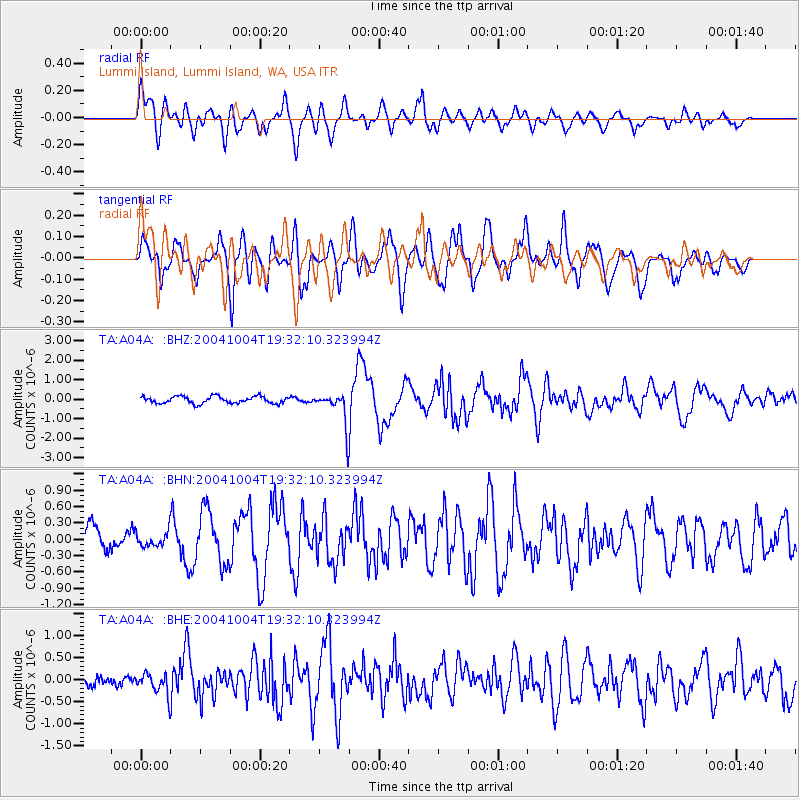
Signal To Noise
| Channel | StoN | STA | LTA |
| TA:A04A: :BHN:20041004T19:32:10.323994Z | 0.5657903 | 1.3118681E-7 | 2.3186472E-7 |
| TA:A04A: :BHE:20041004T19:32:10.323994Z | 1.409184 | 2.37676E-7 | 1.6866215E-7 |
| TA:A04A: :BHZ:20041004T19:32:10.323994Z | 4.857445 | 8.6108315E-7 | 1.772708E-7 |
| Arrivals |
| Ps | 7.6 SECOND |
| PpPs | 24 SECOND |
| PsPs/PpSs | 32 SECOND |


