You are here: Home > Network List > TA - USArray Transportable Network (new EarthScope stations) Stations List
> Station HAST UC Hastings Reserve, Carmel Valley, CA, USA > Earthquake Result Viewer
HAST UC Hastings Reserve, Carmel Valley, CA, USA - Earthquake Result Viewer

| Earthquake location: |
Mariana Islands |
| Earthquake latitude/longitude: |
16.0/145.9 |
| Earthquake time(UTC): |
2005/02/05 (036) 03:34:25 GMT |
| Earthquake Depth: |
143 km |
| Earthquake Magnitude: |
6.3 MB, 6.6 MW, 6.5 MW |
| Earthquake Catalog/Contributor: |
WHDF/NEIC |
|
| Network: |
TA USArray Transportable Network (new EarthScope stations) |
| Station: |
HAST UC Hastings Reserve, Carmel Valley, CA, USA |
| Lat/Lon: |
36.39 N/121.55 W |
| Elevation: |
542 m |
|
| Distance: |
82.7 deg |
| Az: |
54.357 deg |
| Baz: |
284.405 deg |
| Ray Param: |
0.046374604 |
| Estimated Moho Depth: |
22.0 km |
| Estimated Crust Vp/Vs: |
1.88 |
| Assumed Crust Vp: |
6.391 km/s |
| Estimated Crust Vs: |
3.39 km/s |
| Estimated Crust Poisson's Ratio: |
0.30 |
|
| Radial Match: |
92.41008 % |
| Radial Bump: |
400 |
| Transverse Match: |
86.04289 % |
| Transverse Bump: |
400 |
| SOD ConfigId: |
5233 |
| Insert Time: |
2010-03-07 04:37:51.895 +0000 |
| GWidth: |
2.5 |
| Max Bumps: |
400 |
| Tol: |
0.001 |
|
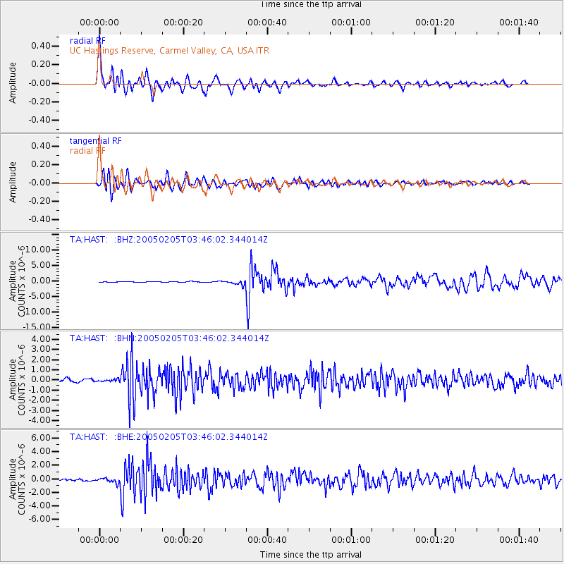
Signal To Noise
| Channel | StoN | STA | LTA |
| TA:HAST: :BHN:20050205T03:46:02.344014Z | 0.6812712 | 1.2114644E-7 | 1.778241E-7 |
| TA:HAST: :BHE:20050205T03:46:02.344014Z | 2.6309936 | 3.3508113E-7 | 1.2735916E-7 |
| TA:HAST: :BHZ:20050205T03:46:02.344014Z | 5.916963 | 6.794264E-7 | 1.1482689E-7 |
| Arrivals |
| Ps | 3.1 SECOND |
| PpPs | 9.7 SECOND |
| PsPs/PpSs | 13 SECOND |


