You are here: Home > Network List > TA - USArray Transportable Network (new EarthScope stations) Stations List
> Station HAST UC Hastings Reserve, Carmel Valley, CA, USA > Earthquake Result Viewer
HAST UC Hastings Reserve, Carmel Valley, CA, USA - Earthquake Result Viewer

| Earthquake location: |
Near East Coast Of Honshu, Japan |
| Earthquake latitude/longitude: |
38.3/142.0 |
| Earthquake time(UTC): |
2005/08/16 (228) 02:46:28 GMT |
| Earthquake Depth: |
36 km |
| Earthquake Magnitude: |
6.5 MB, 6.8 MS, 7.2 MW, 7.1 MW |
| Earthquake Catalog/Contributor: |
WHDF/NEIC |
|
| Network: |
TA USArray Transportable Network (new EarthScope stations) |
| Station: |
HAST UC Hastings Reserve, Carmel Valley, CA, USA |
| Lat/Lon: |
36.39 N/121.55 W |
| Elevation: |
542 m |
|
| Distance: |
72.9 deg |
| Az: |
57.014 deg |
| Baz: |
305.098 deg |
| Ray Param: |
0.053280696 |
| Estimated Moho Depth: |
22.75 km |
| Estimated Crust Vp/Vs: |
1.82 |
| Assumed Crust Vp: |
6.391 km/s |
| Estimated Crust Vs: |
3.511 km/s |
| Estimated Crust Poisson's Ratio: |
0.28 |
|
| Radial Match: |
95.08385 % |
| Radial Bump: |
400 |
| Transverse Match: |
89.11998 % |
| Transverse Bump: |
400 |
| SOD ConfigId: |
2475 |
| Insert Time: |
2010-03-07 04:38:15.861 +0000 |
| GWidth: |
2.5 |
| Max Bumps: |
400 |
| Tol: |
0.001 |
|
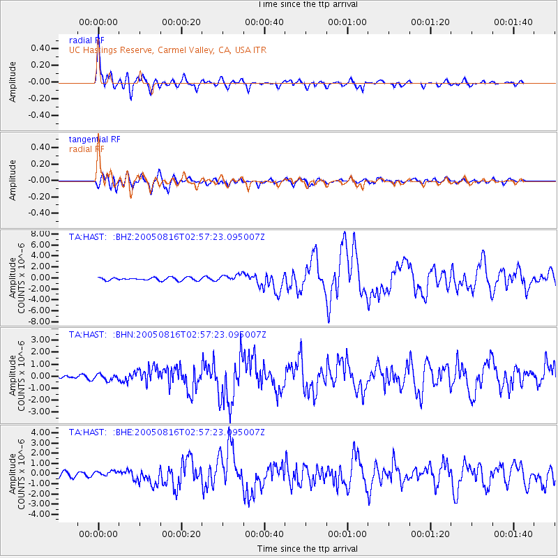
Signal To Noise
| Channel | StoN | STA | LTA |
| TA:HAST: :BHN:20050816T02:57:23.095007Z | 0.96319896 | 2.4087777E-7 | 2.50081E-7 |
| TA:HAST: :BHE:20050816T02:57:23.095007Z | 1.2392157 | 2.8213188E-7 | 2.2766972E-7 |
| TA:HAST: :BHZ:20050816T02:57:23.095007Z | 2.465422 | 6.555768E-7 | 2.6590857E-7 |
| Arrivals |
| Ps | 3.0 SECOND |
| PpPs | 9.7 SECOND |
| PsPs/PpSs | 13 SECOND |


