You are here: Home > Network List > TA - USArray Transportable Network (new EarthScope stations) Stations List
> Station HAST UC Hastings Reserve, Carmel Valley, CA, USA > Earthquake Result Viewer
HAST UC Hastings Reserve, Carmel Valley, CA, USA - Earthquake Result Viewer
| Earthquake location: |
New Britain Region, P.N.G. |
| Earthquake latitude/longitude: |
-5.9/151.0 |
| Earthquake time(UTC): |
2006/10/17 (290) 01:25:12 GMT |
| Earthquake Depth: |
32 km |
| Earthquake Magnitude: |
6.4 MB, 6.9 MS, 6.7 MW, 6.6 MW |
| Earthquake Catalog/Contributor: |
WHDF/NEIC |
|
| Network: |
TA USArray Transportable Network (new EarthScope stations) |
| Station: |
HAST UC Hastings Reserve, Carmel Valley, CA, USA |
| Lat/Lon: |
36.39 N/121.55 W |
| Elevation: |
542 m |
|
| Distance: |
91.4 deg |
| Az: |
53.742 deg |
| Baz: |
263.792 deg |
| Ray Param: |
0.04160016 |
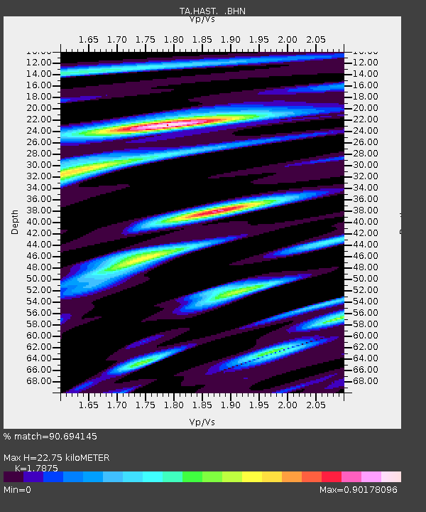
| Estimated Moho Depth: |
22.75 km |
| Estimated Crust Vp/Vs: |
1.79 |
| Assumed Crust Vp: |
6.391 km/s |
| Estimated Crust Vs: |
3.575 km/s |
| Estimated Crust Poisson's Ratio: |
0.27 |
|
| Radial Match: |
90.694145 % |
| Radial Bump: |
400 |
| Transverse Match: |
71.66317 % |
| Transverse Bump: |
400 |
| SOD ConfigId: |
2665 |
| Insert Time: |
2010-03-07 04:38:29.837 +0000 |
| GWidth: |
2.5 |
| Max Bumps: |
400 |
| Tol: |
0.001 |
|
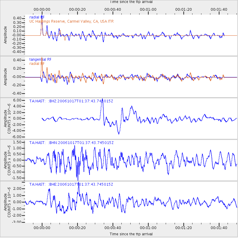
Signal To Noise
| Channel | StoN | STA | LTA |
| TA:HAST: :BHN:20061017T01:37:43.745015Z | 1.4684579 | 3.1894254E-7 | 2.1719555E-7 |
| TA:HAST: :BHE:20061017T01:37:43.745015Z | 4.5500073 | 8.50296E-7 | 1.8687794E-7 |
| TA:HAST: :BHZ:20061017T01:37:43.745015Z | 8.888755 | 2.7085252E-6 | 3.0471367E-7 |
| Arrivals |
| Ps | 2.9 SECOND |
| PpPs | 9.7 SECOND |
| PsPs/PpSs | 13 SECOND |


